
19/01 BAT(2)
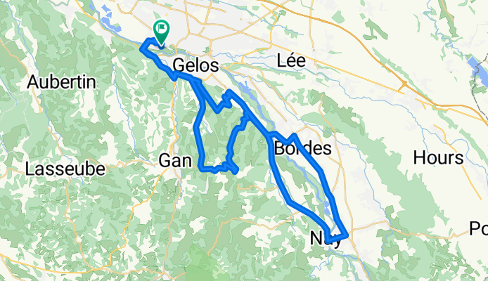
A cycling route starting in Billère, Aquitaine-Limousin-Poitou-Charentes, France.
Overview
About this route
- -:--
- Duration
- 60.7 km
- Distance
- 494 m
- Ascent
- 495 m
- Descent
- ---
- Avg. speed
- ---
- Max. altitude

Route quality
Waytypes & surfaces along the route
Waytypes
Busy road
38.4 km
(63 %)
Quiet road
11.2 km
(18 %)
Surfaces
Paved
35.5 km
(59 %)
Asphalt
35.4 km
(58 %)
Paved (undefined)
0.1 km
(<1 %)
Undefined
25.2 km
(41 %)
Continue with Bikemap
Use, edit, or download this cycling route
You would like to ride 19/01 BAT(2) or customize it for your own trip? Here is what you can do with this Bikemap route:
Free features
- Save this route as favorite or in collections
- Copy & plan your own version of this route
- Sync your route with Garmin or Wahoo
Premium features
Free trial for 3 days, or one-time payment. More about Bikemap Premium.
- Navigate this route on iOS & Android
- Export a GPX / KML file of this route
- Create your custom printout (try it for free)
- Download this route for offline navigation
Discover more Premium features.
Get Bikemap PremiumFrom our community
Other popular routes starting in Billère
 Le 01 mai 2021
- Distance
- 92.4 km
- Ascent
- 675 m
- Descent
- 673 m
- Location
- Billère, Aquitaine-Limousin-Poitou-Charentes, France
 le 17 avril
- Distance
- 87.7 km
- Ascent
- 536 m
- Descent
- 536 m
- Location
- Billère, Aquitaine-Limousin-Poitou-Charentes, France
 29/12
29/12- Distance
- 78.4 km
- Ascent
- 487 m
- Descent
- 488 m
- Location
- Billère, Aquitaine-Limousin-Poitou-Charentes, France
 26/01 BAT
- Distance
- 80 km
- Ascent
- 379 m
- Descent
- 380 m
- Location
- Billère, Aquitaine-Limousin-Poitou-Charentes, France
 LSS Billere Camping - Biarriz
- Distance
- 143.4 km
- Ascent
- 789 m
- Descent
- 944 m
- Location
- Billère, Aquitaine-Limousin-Poitou-Charentes, France
 BAT 66KM 320d+
- Distance
- 65.9 km
- Ascent
- 284 m
- Descent
- 283 m
- Location
- Billère, Aquitaine-Limousin-Poitou-Charentes, France
 La chapelle de rousse - 2
- Distance
- 27.5 km
- Ascent
- 352 m
- Descent
- 388 m
- Location
- Billère, Aquitaine-Limousin-Poitou-Charentes, France
 De Lons au col de Spandelles (A/R)
- Distance
- 107.5 km
- Ascent
- 1,500 m
- Descent
- 1,500 m
- Location
- Billère, Aquitaine-Limousin-Poitou-Charentes, France
Open it in the app