

Circuit des vallées de la Seine n°3 AS BARBEREY
A cycling route starting in Saint-Parres-aux-Tertres, Grand Est, France.
Overview
About this route
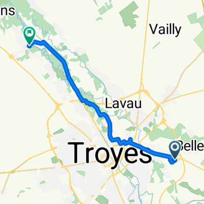
Parcours 55 Kms : St Parres - Av henri Barbusse - Rond-point 1ier Mai - Rue Etienne Pédron - Fouchy - Route de Culoison - Ste Maure - St Benoit - Villacerf - Chapelle Vallon - Vouè - Montsuzain - Charmont (pointage) - Luyères - Creney - Villechètif - St Parres.
- -:--
- Duration
- 54.8 km
- Distance
- 202 m
- Ascent
- 199 m
- Descent
- ---
- Avg. speed
- ---
- Max. altitude

Route quality
Waytypes & surfaces along the route
Waytypes
Road
36.2 km
(66 %)
Quiet road
2.7 km
(5 %)
Surfaces
Paved
24.7 km
(45 %)
Asphalt
24.7 km
(45 %)
Undefined
30.1 km
(55 %)
Continue with Bikemap
Use, edit, or download this cycling route
You would like to ride Circuit des vallées de la Seine n°3 AS BARBEREY or customize it for your own trip? Here is what you can do with this Bikemap route:
Free features
- Save this route as favorite or in collections
- Copy & plan your own version of this route
- Sync your route with Garmin or Wahoo
Premium features
Free trial for 3 days, or one-time payment. More about Bikemap Premium.
- Navigate this route on iOS & Android
- Export a GPX / KML file of this route
- Create your custom printout (try it for free)
- Download this route for offline navigation
Discover more Premium features.
Get Bikemap PremiumFrom our community
Other popular routes starting in Saint-Parres-aux-Tertres
 Vallée de la Seine Parcours N°2
- Distance
- 66.1 km
- Ascent
- 264 m
- Descent
- 265 m
- Location
- Saint-Parres-aux-Tertres, Grand Est, France
 Route de la Charme, Villechétif à 7 Rue de l'Église, Barberey-Saint-Sulpice
- Distance
- 12.9 km
- Ascent
- 345 m
- Descent
- 450 m
- Location
- Saint-Parres-aux-Tertres, Grand Est, France
 Circuit des vallées de la Seine n°3 AS BARBEREY
- Distance
- 54.8 km
- Ascent
- 202 m
- Descent
- 199 m
- Location
- Saint-Parres-aux-Tertres, Grand Est, France
 Brevet permanent n° 9 des randonnées Bréviandoises
- Distance
- 59.9 km
- Ascent
- 167 m
- Descent
- 167 m
- Location
- Saint-Parres-aux-Tertres, Grand Est, France
 34 Avenue du Général de Gaulle, Saint-Parres-aux-Tertres à 4 Rue Robert Keller, Pont-Sainte-Marie
- Distance
- 4.9 km
- Ascent
- 11 m
- Descent
- 18 m
- Location
- Saint-Parres-aux-Tertres, Grand Est, France
 Champagne dag 1
- Distance
- 26.1 km
- Ascent
- 71 m
- Descent
- 72 m
- Location
- Saint-Parres-aux-Tertres, Grand Est, France
 Brevet permanent n° 6 des randonnées Bréviandoises.
- Distance
- 53.6 km
- Ascent
- 259 m
- Descent
- 259 m
- Location
- Saint-Parres-aux-Tertres, Grand Est, France
 2–6 Rue des Châtaigniers, Saint-Parres-aux-Tertres à 2 Rue des Martyrs de la Résistance, Saint-Lyé
- Distance
- 15 km
- Ascent
- 101 m
- Descent
- 121 m
- Location
- Saint-Parres-aux-Tertres, Grand Est, France
Open it in the app