

Overview
About this route
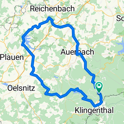
Z Mühlleitenu po Kammloipe. Odboka /6,5/ na Přední Ostružník a po KLM na Rolavu /11./ a dále na Jelení /16./. Pokračujeme po KLM a na Hamerkém rozcestí /23./ odbočit na Pernink /27/
- -:--
- Duration
- 27.1 km
- Distance
- 393 m
- Ascent
- 419 m
- Descent
- ---
- Avg. speed
- ---
- Max. altitude

Part of
Krušné hory
3 stages
Route quality
Waytypes & surfaces along the route
Waytypes
Track
16.1 km
(60 %)
Road
9.5 km
(35 %)
Surfaces
Paved
16.1 km
(59 %)
Unpaved
10 km
(37 %)
Asphalt
15.7 km
(58 %)
Loose gravel
4.2 km
(15 %)
Continue with Bikemap
Use, edit, or download this cycling route
You would like to ride ZP KH Mühlleiten - PERNINK or customize it for your own trip? Here is what you can do with this Bikemap route:
Free features
- Save this route as favorite or in collections
- Copy & plan your own version of this route
- Sync your route with Garmin or Wahoo
Premium features
Free trial for 3 days, or one-time payment. More about Bikemap Premium.
- Navigate this route on iOS & Android
- Export a GPX / KML file of this route
- Create your custom printout (try it for free)
- Download this route for offline navigation
Discover more Premium features.
Get Bikemap PremiumFrom our community
Other popular routes starting in Tannenbergsthal
 Gabriel-Baumann-Straße 8, Muldenhammer nach Klingenthaler Straße 3, Muldenhammer
- Distance
- 42.7 km
- Ascent
- 1,299 m
- Descent
- 1,282 m
- Location
- Tannenbergsthal, Saxony, Germany
 TBT - Klingenthal - TBT
- Distance
- 25.2 km
- Ascent
- 500 m
- Descent
- 500 m
- Location
- Tannenbergsthal, Saxony, Germany
 Vogtlandritt
- Distance
- 61.8 km
- Ascent
- 787 m
- Descent
- 925 m
- Location
- Tannenbergsthal, Saxony, Germany
 ZP KH Mühlleiten - PERNINK
- Distance
- 27.1 km
- Ascent
- 393 m
- Descent
- 419 m
- Location
- Tannenbergsthal, Saxony, Germany
 Zusatz Männerstagsride zum Schneckenstein (Tannenbergsthal)
- Distance
- 9 km
- Ascent
- 231 m
- Descent
- 200 m
- Location
- Tannenbergsthal, Saxony, Germany
 Freeride & Downhill
- Distance
- 31.9 km
- Ascent
- 1,003 m
- Descent
- 1,000 m
- Location
- Tannenbergsthal, Saxony, Germany
 Kammtour Erzgebirge Auf dem höchsten Weg durch Sachsen und Böhmen - Kammtour Erzgebirge Auf dem höchsten Weg durch Sachsen und Böhmen
- Distance
- 233.8 km
- Ascent
- 2,873 m
- Descent
- 3,132 m
- Location
- Tannenbergsthal, Saxony, Germany
 Vogtland -2-
- Distance
- 93.5 km
- Ascent
- 1,141 m
- Descent
- 1,149 m
- Location
- Tannenbergsthal, Saxony, Germany
Open it in the app