Catbalogan-Lagundi-Cawayan-StoNino
- 10.2 km
- 366 m
- 370 m
- Catbalogan, Region VIII, Philippines
A cycling route starting in Catbalogan, Region VIII, Philippines.
Overview
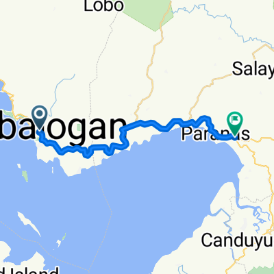
J16 - Friday, January 25, 2019 – Catbalogan (Samar) – Tacloban (Leyte)
Distance covered: 106.94 km - Average: 15.65 km/h
Elevation gain: 905 m - Maximum uphill gradient: 12 %
Elevation loss: 905 m - Maximum downhill gradient: 5 %
Starting altitude: 7 m - Finishing altitude: 7 m - Maximum altitude: 153 m
Wake-up time: 6:30 - Departure time: 7:53 - Arrival time: 17:30
created this 6 years ago
Route quality
Cycleway
88.8 km
(82 %)
Quiet road
9.7 km
(9 %)
Paved
70.4 km
(65 %)
Unpaved
2.2 km
(2 %)
Asphalt
58.5 km
(54 %)
Concrete
6.5 km
(6 %)
Continue with Bikemap
You would like to ride J16 - vendredi 25 janvier 2019 – Catbalogan (Samar) – Tacloban (Leyte) or customize it for your own trip? Here is what you can do with this Bikemap route:
Free trial for 3 days, or one-time payment. More about Bikemap Premium.
Discover more Premium features.
Get Bikemap PremiumFrom our community
Open it in the app