

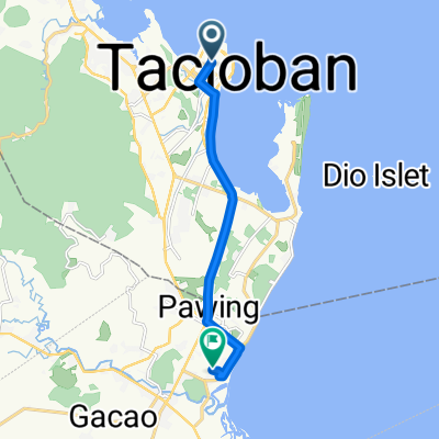
J17 - samedi 26 janvier 2019 – Tacloban repos et visite
A cycling route starting in Panalanoy, Region VIII, Philippines.
Overview
About this route
J17 - Saturday, January 26, 2019 – Tacloban rest and visit
Distance covered: 32.59 km - Average speed: 11.59 km/h
Ascent: 25 m - Maximum climbing gradient: 4 %
Descent: 25 m - Maximum descending gradient: 4 %
Starting altitude: 7 m - Arrival altitude: 7 m - Maximum altitude: 31 m
Wake-up time: 6:30 - Departure time: 9:52 - Arrival time: 15:45
- -:--
- Duration
- 33.6 km
- Distance
- 40 m
- Ascent
- 38 m
- Descent
- ---
- Avg. speed
- ---
- Max. altitude
Continue with Bikemap
Use, edit, or download this cycling route
You would like to ride J17 - samedi 26 janvier 2019 – Tacloban repos et visite or customize it for your own trip? Here is what you can do with this Bikemap route:
Free features
- Save this route as favorite or in collections
- Copy & plan your own version of this route
- Sync your route with Garmin or Wahoo
Premium features
Free trial for 3 days, or one-time payment. More about Bikemap Premium.
- Navigate this route on iOS & Android
- Export a GPX / KML file of this route
- Create your custom printout (try it for free)
- Download this route for offline navigation
Discover more Premium features.
Get Bikemap PremiumFrom our community
Other popular routes starting in Panalanoy
 J17 - samedi 26 janvier 2019 – Tacloban repos et visite
- Distance
- 33.6 km
- Ascent
- 40 m
- Descent
- 38 m
- Location
- Panalanoy, Region VIII, Philippines
 Maharlika Highway, Tacloban to Barangay 110 (Utap), Tacloban
- Distance
- 16.7 km
- Ascent
- 54 m
- Descent
- 52 m
- Location
- Panalanoy, Region VIII, Philippines
 ytjuerrtear
- Distance
- 4.2 km
- Ascent
- 23 m
- Descent
- 20 m
- Location
- Panalanoy, Region VIII, Philippines
 Sta. Cruz Street 108, Tacloban City to Palo - Santa Fe Road
- Distance
- 31.1 km
- Ascent
- 296 m
- Descent
- 286 m
- Location
- Panalanoy, Region VIII, Philippines
 july 11
- Distance
- 2.6 km
- Ascent
- 32 m
- Descent
- 28 m
- Location
- Panalanoy, Region VIII, Philippines
 M.H. Del Pilar Street 92, Tacloban City to Unnamed Road, Palo
- Distance
- 10.8 km
- Ascent
- 70 m
- Descent
- 69 m
- Location
- Panalanoy, Region VIII, Philippines
 pogogo
- Distance
- 3.9 km
- Ascent
- 19 m
- Descent
- 19 m
- Location
- Panalanoy, Region VIII, Philippines
 Tacloban City to Tacloban City
- Distance
- 19.4 km
- Ascent
- 20 m
- Descent
- 19 m
- Location
- Panalanoy, Region VIII, Philippines
Open it in the app