

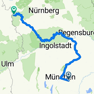
Zorneding-Unterelkhofen
A cycling route starting in Zorneding, Bavaria, Germany.
Overview
About this route
Zorneding, Bahnhofstr. (P+R)
Schloßgaststätte Unterelkhofen
Tuesday- Sunday 10.00-21.00 Hour
Rest day: Monday
- -:--
- Duration
- 57.1 km
- Distance
- 350 m
- Ascent
- 350 m
- Descent
- ---
- Avg. speed
- ---
- Max. altitude

Route quality
Waytypes & surfaces along the route
Waytypes
Quiet road
37.1 km
(65 %)
Road
10.3 km
(18 %)
Surfaces
Paved
50.2 km
(88 %)
Unpaved
5.1 km
(9 %)
Asphalt
50.2 km
(88 %)
Gravel
5.1 km
(9 %)
Undefined
1.7 km
(3 %)
Route highlights
Points of interest along the route
Accommodation after 35.7 km
Schloßgaststätte Unterelkhofen
Continue with Bikemap
Use, edit, or download this cycling route
You would like to ride Zorneding-Unterelkhofen or customize it for your own trip? Here is what you can do with this Bikemap route:
Free features
- Save this route as favorite or in collections
- Copy & plan your own version of this route
- Sync your route with Garmin or Wahoo
Premium features
Free trial for 3 days, or one-time payment. More about Bikemap Premium.
- Navigate this route on iOS & Android
- Export a GPX / KML file of this route
- Create your custom printout (try it for free)
- Download this route for offline navigation
Discover more Premium features.
Get Bikemap PremiumFrom our community
Other popular routes starting in Zorneding
 Zorneding-Unterelkhofen
- Distance
- 57.1 km
- Ascent
- 350 m
- Descent
- 350 m
- Location
- Zorneding, Bavaria, Germany
 Zorneding-Isar Radweg - Altmuel Tauber Radweg
- Distance
- 407.9 km
- Ascent
- 2,093 m
- Descent
- 2,229 m
- Location
- Zorneding, Bavaria, Germany
 Zorneding-Isar Radweg - Altmuel Tauber Radweg_dolga
- Distance
- 481.6 km
- Ascent
- 3,653 m
- Descent
- 4,059 m
- Location
- Zorneding, Bavaria, Germany
 Panorama-Route bayr. Oberland
- Distance
- 55.8 km
- Ascent
- 630 m
- Descent
- 600 m
- Location
- Zorneding, Bavaria, Germany
 Erding
- Distance
- 63.8 km
- Ascent
- 127 m
- Descent
- 127 m
- Location
- Zorneding, Bavaria, Germany
 Piusheim
- Distance
- 58.2 km
- Ascent
- 364 m
- Descent
- 368 m
- Location
- Zorneding, Bavaria, Germany
 Mistelweg nach Fuchsweg
- Distance
- 12.5 km
- Ascent
- 51 m
- Descent
- 100 m
- Location
- Zorneding, Bavaria, Germany
 Schnelle Runde Zorneding - Aßling - G'höhenrain
- Distance
- 45.6 km
- Ascent
- 576 m
- Descent
- 566 m
- Location
- Zorneding, Bavaria, Germany
Open it in the app