

Esos pueblos que los ponen por las noches
A cycling route starting in Miraflores de la Sierra, Madrid, Spain.
Overview
About this route
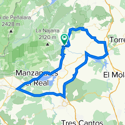
Miraflores-Cubillo de Uceda-Espartal
- -:--
- Duration
- 99 km
- Distance
- 912 m
- Ascent
- 911 m
- Descent
- ---
- Avg. speed
- ---
- Max. altitude

Route quality
Waytypes & surfaces along the route
Waytypes
Road
29.7 km
(30 %)
Quiet road
14.9 km
(15 %)
Surfaces
Paved
5 km
(5 %)
Unpaved
8.9 km
(9 %)
Gravel
5 km
(5 %)
Asphalt
4 km
(4 %)
Continue with Bikemap
Use, edit, or download this cycling route
You would like to ride Esos pueblos que los ponen por las noches or customize it for your own trip? Here is what you can do with this Bikemap route:
Free features
- Save this route as favorite or in collections
- Copy & plan your own version of this route
- Split it into stages to create a multi-day tour
- Sync your route with Garmin or Wahoo
Premium features
Free trial for 3 days, or one-time payment. More about Bikemap Premium.
- Navigate this route on iOS & Android
- Export a GPX / KML file of this route
- Create your custom printout (try it for free)
- Download this route for offline navigation
Discover more Premium features.
Get Bikemap PremiumFrom our community
Other popular routes starting in Miraflores de la Sierra
 miraflores-la morcuera-canencia
- Distance
- 31.7 km
- Ascent
- 729 m
- Descent
- 729 m
- Location
- Miraflores de la Sierra, Madrid, Spain
 Miraflores-Morcuera-Rascafría-Majada Cojo 07.07.12
- Distance
- 57.2 km
- Ascent
- 1,333 m
- Descent
- 1,333 m
- Location
- Miraflores de la Sierra, Madrid, Spain
 Miraflores-Atazar
- Distance
- 90.9 km
- Ascent
- 1,044 m
- Descent
- 1,045 m
- Location
- Miraflores de la Sierra, Madrid, Spain
 Miraflores- Hoyo de Manzanares
- Distance
- 85.7 km
- Ascent
- 1,025 m
- Descent
- 1,024 m
- Location
- Miraflores de la Sierra, Madrid, Spain
 Puerto de Morcuera y Puerto de Canencia
- Distance
- 79.3 km
- Ascent
- 1,347 m
- Descent
- 1,347 m
- Location
- Miraflores de la Sierra, Madrid, Spain
 Restful route in Soto del Real
- Distance
- 35.7 km
- Ascent
- 367 m
- Descent
- 368 m
- Location
- Miraflores de la Sierra, Madrid, Spain
 Ruta Sierra 03: 88 Km 1687 m - "Morcuera y Cotos"
- Distance
- 86.4 km
- Ascent
- 1,588 m
- Descent
- 1,589 m
- Location
- Miraflores de la Sierra, Madrid, Spain
 Miraflores-CerroSanPedro-Navalafuente-Bustarviejo-Miraflores
- Distance
- 86.9 km
- Ascent
- 769 m
- Descent
- 769 m
- Location
- Miraflores de la Sierra, Madrid, Spain
Open it in the app