
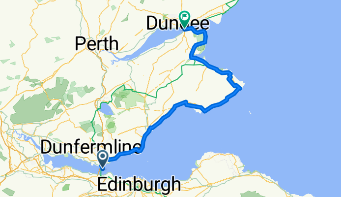
Mental Health Week Route
A cycling route starting in North Queensferry, Scotland, United Kingdom.
Overview
About this route
- -:--
- Duration
- 117.6 km
- Distance
- 356 m
- Ascent
- 348 m
- Descent
- ---
- Avg. speed
- ---
- Max. altitude

Route quality
Waytypes & surfaces along the route
Waytypes
Track
20 km
(17 %)
Quiet road
18.8 km
(16 %)
Surfaces
Paved
62.3 km
(53 %)
Unpaved
21.2 km
(18 %)
Asphalt
61.2 km
(52 %)
Gravel
14.1 km
(12 %)
Continue with Bikemap
Use, edit, or download this cycling route
You would like to ride Mental Health Week Route or customize it for your own trip? Here is what you can do with this Bikemap route:
Free features
- Save this route as favorite or in collections
- Copy & plan your own version of this route
- Split it into stages to create a multi-day tour
- Sync your route with Garmin or Wahoo
Premium features
Free trial for 3 days, or one-time payment. More about Bikemap Premium.
- Navigate this route on iOS & Android
- Export a GPX / KML file of this route
- Create your custom printout (try it for free)
- Download this route for offline navigation
Discover more Premium features.
Get Bikemap PremiumFrom our community
Other popular routes starting in North Queensferry
 St Margaret's Loop
- Distance
- 11.3 km
- Ascent
- 138 m
- Descent
- 95 m
- Location
- North Queensferry, Scotland, United Kingdom
 North Queensferry to Noah's Ark, Perth
- Distance
- 57.3 km
- Ascent
- 560 m
- Descent
- 506 m
- Location
- North Queensferry, Scotland, United Kingdom
 Brock Street 62, North Queensferry to Port Laing Wynd 1, North Queensferry
- Distance
- 19.6 km
- Ascent
- 340 m
- Descent
- 449 m
- Location
- North Queensferry, Scotland, United Kingdom
 Mental Health Week Route
- Distance
- 117.6 km
- Ascent
- 356 m
- Descent
- 348 m
- Location
- North Queensferry, Scotland, United Kingdom
 16 Carlingnose Way, Inverkeithing to 17 Carlingnose Way, Inverkeithing
- Distance
- 33.3 km
- Ascent
- 1,171 m
- Descent
- 1,191 m
- Location
- North Queensferry, Scotland, United Kingdom
 Forth to Seahouses
- Distance
- 178.6 km
- Ascent
- 610 m
- Descent
- 640 m
- Location
- North Queensferry, Scotland, United Kingdom
 North_Queensferry_Portobello
- Distance
- 34 km
- Ascent
- 276 m
- Descent
- 278 m
- Location
- North Queensferry, Scotland, United Kingdom
 Battery Road Turning Circle, North Queensferry to Dovecot Wynd 23
- Distance
- 8.8 km
- Ascent
- 95 m
- Descent
- 105 m
- Location
- North Queensferry, Scotland, United Kingdom
Open it in the app