

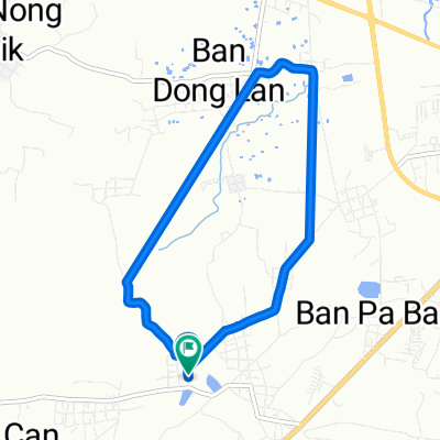
28/01/2562
A cycling route starting in Roi Et, Roi Et, Thailand.
Overview
About this route
- 49 min
- Duration
- 14 km
- Distance
- 451 m
- Ascent
- 437 m
- Descent
- 17.2 km/h
- Avg. speed
- ---
- Max. altitude

Route photos

Route quality
Waytypes & surfaces along the route
Waytypes
Quiet road
12.1 km
(86 %)
Access road
1.1 km
(8 %)
Surfaces
Paved
0.2 km
(1 %)
Asphalt
0.2 km
(1 %)
Undefined
13.8 km
(99 %)
Continue with Bikemap
Use, edit, or download this cycling route
You would like to ride 28/01/2562 or customize it for your own trip? Here is what you can do with this Bikemap route:
Free features
- Save this route as favorite or in collections
- Copy & plan your own version of this route
- Sync your route with Garmin or Wahoo
Premium features
Free trial for 3 days, or one-time payment. More about Bikemap Premium.
- Navigate this route on iOS & Android
- Export a GPX / KML file of this route
- Create your custom printout (try it for free)
- Download this route for offline navigation
Discover more Premium features.
Get Bikemap PremiumFrom our community
Other popular routes starting in Roi Et
 28/01/2562
- Distance
- 14 km
- Ascent
- 451 m
- Descent
- 437 m
- Location
- Roi Et, Roi Et, Thailand
 27/01/2562
- Distance
- 14.7 km
- Ascent
- 158 m
- Descent
- 156 m
- Location
- Roi Et, Roi Et, Thailand
 08/02/2562. P2
- Distance
- 14.8 km
- Ascent
- 169 m
- Descent
- 153 m
- Location
- Roi Et, Roi Et, Thailand
 01/02/2562
- Distance
- 15.7 km
- Ascent
- 237 m
- Descent
- 225 m
- Location
- Roi Et, Roi Et, Thailand
 2HGX+P8F to 2HGX+P8F
- Distance
- 9.7 km
- Ascent
- 29 m
- Descent
- 20 m
- Location
- Roi Et, Roi Et, Thailand
 30 พ.ย. 2557 06:41
- Distance
- 15.5 km
- Ascent
- 15 m
- Descent
- 19 m
- Location
- Roi Et, Roi Et, Thailand
 29 ธ.ค. 2557 17:31
- Distance
- 5 km
- Ascent
- 4 m
- Descent
- 4 m
- Location
- Roi Et, Roi Et, Thailand
 8 ก.พ. 2558 18:00
- Distance
- 11.2 km
- Ascent
- 11 m
- Descent
- 4 m
- Location
- Roi Et, Roi Et, Thailand
Open it in the app