

Presidents Ride Day 2
A cycling route starting in Ampthill, England, United Kingdom.
Overview
About this route
2nd day of the Presidents Ride finshing at Bedford Blues. Start time 11.00 end time 12.30.
- -:--
- Duration
- 30.4 km
- Distance
- 128 m
- Ascent
- 195 m
- Descent
- ---
- Avg. speed
- ---
- Max. altitude
Route quality
Waytypes & surfaces along the route
Waytypes
Road
23.1 km
(76 %)
Quiet road
4.3 km
(14 %)
Surfaces
Paved
1.8 km
(6 %)
Unpaved
0.3 km
(1 %)
Asphalt
1.5 km
(5 %)
Concrete
0.3 km
(1 %)
Continue with Bikemap
Use, edit, or download this cycling route
You would like to ride Presidents Ride Day 2 or customize it for your own trip? Here is what you can do with this Bikemap route:
Free features
- Save this route as favorite or in collections
- Copy & plan your own version of this route
- Sync your route with Garmin or Wahoo
Premium features
Free trial for 3 days, or one-time payment. More about Bikemap Premium.
- Navigate this route on iOS & Android
- Export a GPX / KML file of this route
- Create your custom printout (try it for free)
- Download this route for offline navigation
Discover more Premium features.
Get Bikemap PremiumFrom our community
Other popular routes starting in Ampthill
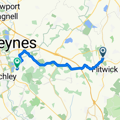 Flitwick Road, Bedford to Station Road, Milton Keynes
- Distance
- 20.5 km
- Ascent
- 169 m
- Descent
- 178 m
- Location
- Ampthill, England, United Kingdom
 IRC Sportive
- Distance
- 129.9 km
- Ascent
- 430 m
- Descent
- 430 m
- Location
- Ampthill, England, United Kingdom
 ToB Segment 3
- Distance
- 76.2 km
- Ascent
- 594 m
- Descent
- 594 m
- Location
- Ampthill, England, United Kingdom
 Ampthill/Bedford Circuit
- Distance
- 53 km
- Ascent
- 205 m
- Descent
- 200 m
- Location
- Ampthill, England, United Kingdom
 12 Glebe Road, Bedford to Bentworth Road Park, Bentworth Road, London
- Distance
- 78.8 km
- Ascent
- 482 m
- Descent
- 551 m
- Location
- Ampthill, England, United Kingdom
 hitchin loop
- Distance
- 63.2 km
- Ascent
- 247 m
- Descent
- 331 m
- Location
- Ampthill, England, United Kingdom
 Ampthyill Willington
- Distance
- 18.5 km
- Ascent
- 41 m
- Descent
- 114 m
- Location
- Ampthill, England, United Kingdom
 Dunstable Street 114, Ampthill to Woburn Street 7, Ampthill
- Distance
- 51.8 km
- Ascent
- 268 m
- Descent
- 267 m
- Location
- Ampthill, England, United Kingdom
Open it in the app