
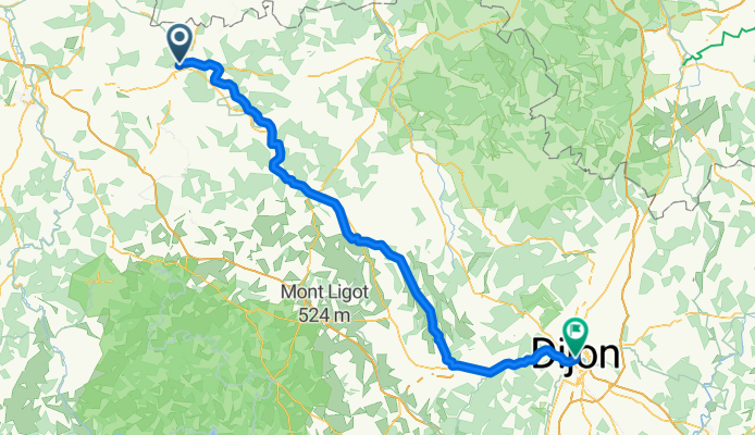
canal burgundy
A cycling route starting in Tonnerre, Bourgogne-Franche-Comté, France.
Overview
About this route
- -:--
- Duration
- 130.1 km
- Distance
- 523 m
- Ascent
- 425 m
- Descent
- ---
- Avg. speed
- ---
- Max. altitude

Route quality
Waytypes & surfaces along the route
Waytypes
Road
45.5 km
(35 %)
Path
32.5 km
(25 %)
Surfaces
Paved
49.4 km
(38 %)
Unpaved
18.2 km
(14 %)
Asphalt
49.4 km
(38 %)
Loose gravel
10.4 km
(8 %)
Continue with Bikemap
Use, edit, or download this cycling route
You would like to ride canal burgundy or customize it for your own trip? Here is what you can do with this Bikemap route:
Free features
- Save this route as favorite or in collections
- Copy & plan your own version of this route
- Split it into stages to create a multi-day tour
- Sync your route with Garmin or Wahoo
Premium features
Free trial for 3 days, or one-time payment. More about Bikemap Premium.
- Navigate this route on iOS & Android
- Export a GPX / KML file of this route
- Create your custom printout (try it for free)
- Download this route for offline navigation
Discover more Premium features.
Get Bikemap PremiumFrom our community
Other popular routes starting in Tonnerre
 Camino 2015 08b Tonnerre nach Auxerre
- Distance
- 67.1 km
- Ascent
- 93 m
- Descent
- 112 m
- Location
- Tonnerre, Bourgogne-Franche-Comté, France
 Tonnerre - Néronville
- Distance
- 117.3 km
- Ascent
- 292 m
- Descent
- 342 m
- Location
- Tonnerre, Bourgogne-Franche-Comté, France
 2017_E9_Tonnerre_Monéteau
- Distance
- 73 km
- Ascent
- 161 m
- Descent
- 200 m
- Location
- Tonnerre, Bourgogne-Franche-Comté, France
 Tonnerre-Nuits sur Armençon
- Distance
- 17 km
- Ascent
- 0 m
- Descent
- 0 m
- Location
- Tonnerre, Bourgogne-Franche-Comté, France
 Halluin-Montsauche-les-settons
- Distance
- 524.6 km
- Ascent
- 1,324 m
- Descent
- 1,431 m
- Location
- Tonnerre, Bourgogne-Franche-Comté, France
 Rue de la Fosse Dionne, Tonnerre to Le Moulin Neuf, Ancy-le-Franc
- Distance
- 31.5 km
- Ascent
- 77 m
- Descent
- 45 m
- Location
- Tonnerre, Bourgogne-Franche-Comté, France
 Camino 2015 8c Tonnerre nach Auxerre - Chemin de Halage
- Distance
- 71.4 km
- Ascent
- 40 m
- Descent
- 77 m
- Location
- Tonnerre, Bourgogne-Franche-Comté, France
 MORVAN D4 Les mulots-Montsauches-les-settons
- Distance
- 99.3 km
- Ascent
- 1,038 m
- Descent
- 760 m
- Location
- Tonnerre, Bourgogne-Franche-Comté, France
Open it in the app