

Blackalls Park to North Toronto Industrial Estate then home through Fassifern
A cycling route starting in Fennell Bay, New South Wales, Australia.
Overview
About this route
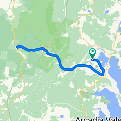
Leave Blackalls Park PS travelling east on Todd Street. Cross South Parade to the Greenway-Cycleway and travel south-east to Stoney Creek.
Join Cook Street at Stoney Creek and travel south turning left into James Street at the tennis courts/bowling green.
Turn left onto Cary Street and travel north to Nelson Street. Turn left into Nelson then right into Oak Street.
Take a right at Day Street, carefully crossing the busy Cary Street and right turn into Renwick Street. Travel south past Toronto Public School and immediately turn right into Bay Street (passing McDonald's Toronto).
Cross Cary Street at the traffic lights in front of McDonald's and proceed a short way south adjacent to Cary Street.
Turn right onto the Greenway-Cycleway and head back through Blackalls Park in a generally north-westerly direction.
Continue on to the Fassifern Greenway-Cycleway intersection whereupon you could make a U-turn.
Head back south a few hundred metres and exit the Greenway at Rose Street. Travel west. Cross South Parade and immediately divert into Rupert Street. Travel (generally) south west about 200m and arrive at Blackalls Park Public School at the intersection of Todd Street.
A slow rider (such as me) can manage this rout in 26-33 minutes even on a 37C (100F) day such as today. DRINK PLENTY!
- -:--
- Duration
- 8.5 km
- Distance
- 74 m
- Ascent
- 48 m
- Descent
- ---
- Avg. speed
- ---
- Max. altitude

Continue with Bikemap
Use, edit, or download this cycling route
You would like to ride Blackalls Park to North Toronto Industrial Estate then home through Fassifern or customize it for your own trip? Here is what you can do with this Bikemap route:
Free features
- Save this route as favorite or in collections
- Copy & plan your own version of this route
- Sync your route with Garmin or Wahoo
Premium features
Free trial for 3 days, or one-time payment. More about Bikemap Premium.
- Navigate this route on iOS & Android
- Export a GPX / KML file of this route
- Create your custom printout (try it for free)
- Download this route for offline navigation
Discover more Premium features.
Get Bikemap PremiumFrom our community
Other popular routes starting in Fennell Bay
 Blackalls Park - THS - Toronto - home - 10.5km
- Distance
- 10.7 km
- Ascent
- 81 m
- Descent
- 80 m
- Location
- Fennell Bay, New South Wales, Australia
 Bay Lap and Lunch at McCafe TOR
- Distance
- 13 km
- Ascent
- 84 m
- Descent
- 81 m
- Location
- Fennell Bay, New South Wales, Australia
 BPPS to Freemans Waterhole Subway
- Distance
- 28.6 km
- Ascent
- 197 m
- Descent
- 197 m
- Location
- Fennell Bay, New South Wales, Australia
 13.5km plus Suburban Run
- Distance
- 14.2 km
- Ascent
- 80 m
- Descent
- 83 m
- Location
- Fennell Bay, New South Wales, Australia
 Toronto Pool (short) + Back Home (long)
- Distance
- 12.1 km
- Ascent
- 109 m
- Descent
- 106 m
- Location
- Fennell Bay, New South Wales, Australia
 Toronto High School, Coles, home
- Distance
- 16.7 km
- Ascent
- 84 m
- Descent
- 88 m
- Location
- Fennell Bay, New South Wales, Australia
 Another Local Suburban Exercise Course
- Distance
- 11.9 km
- Ascent
- 83 m
- Descent
- 86 m
- Location
- Fennell Bay, New South Wales, Australia
 Circumnavigate Edmonds Bay/Stoney Creek
- Distance
- 9.2 km
- Ascent
- 54 m
- Descent
- 63 m
- Location
- Fennell Bay, New South Wales, Australia
Open it in the app