

Erft-Ahr-Rhein
EAR00_Erft-Ahr-Rhein
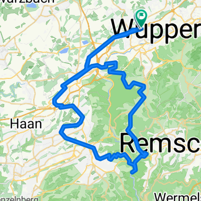
A cycling route starting in Wuppertal, North Rhine-Westphalia, Germany.
Overview
About this route
Start: Wuppertal
Über: Düsseldorfg - Grevenbroich - Bergheim - Liblar - Bad Münstereifel - Blankenheim - Hönningen - Bad Neuenahr - Remagen - Königswinter - Bonn - Köln - Monheim - Hilden - Haan
Ziel: Wuppertal
- -:--
- Duration
- 353 km
- Distance
- 777 m
- Ascent
- 777 m
- Descent
- ---
- Avg. speed
- ---
- Max. altitude

Part of
Erft-Ahr-Rhein
8 stages
Route quality
Waytypes & surfaces along the route
Waytypes
Path
120 km
(34 %)
Track
70.6 km
(20 %)
Surfaces
Paved
240 km
(68 %)
Unpaved
42.4 km
(12 %)
Asphalt
208.3 km
(59 %)
Paved (undefined)
28.2 km
(8 %)
Continue with Bikemap
Use, edit, or download this cycling route
You would like to ride EAR00_Erft-Ahr-Rhein or customize it for your own trip? Here is what you can do with this Bikemap route:
Free features
- Save this route as favorite or in collections
- Copy & plan your own version of this route
- Split it into stages to create a multi-day tour
- Sync your route with Garmin or Wahoo
Premium features
Free trial for 3 days, or one-time payment. More about Bikemap Premium.
- Navigate this route on iOS & Android
- Export a GPX / KML file of this route
- Create your custom printout (try it for free)
- Download this route for offline navigation
Discover more Premium features.
Get Bikemap PremiumFrom our community
Other popular routes starting in Wuppertal
 Wichlinghausen - Wuppertalsperre
- Distance
- 38.7 km
- Ascent
- 349 m
- Descent
- 349 m
- Location
- Wuppertal, North Rhine-Westphalia, Germany
 Nordbahn - Sambatrasse - Müngstener-Brücke - Bergbahn - Korkenzieher
- Distance
- 53.2 km
- Ascent
- 391 m
- Descent
- 392 m
- Location
- Wuppertal, North Rhine-Westphalia, Germany
 WU01_Home_Schee_Horath
- Distance
- 29.7 km
- Ascent
- 387 m
- Descent
- 387 m
- Location
- Wuppertal, North Rhine-Westphalia, Germany
 Südhöhentour
- Distance
- 35.6 km
- Ascent
- 486 m
- Descent
- 511 m
- Location
- Wuppertal, North Rhine-Westphalia, Germany
 Marscheider MTB Zirkel 1
- Distance
- 49.4 km
- Ascent
- 1,041 m
- Descent
- 1,044 m
- Location
- Wuppertal, North Rhine-Westphalia, Germany
 Sambatrasse
- Distance
- 4.8 km
- Ascent
- 140 m
- Descent
- 32 m
- Location
- Wuppertal, North Rhine-Westphalia, Germany
 Tour zur Wuppertalsperre
- Distance
- 42.3 km
- Ascent
- 471 m
- Descent
- 471 m
- Location
- Wuppertal, North Rhine-Westphalia, Germany
 Dönberg-Baldeney-See
- Distance
- 47.7 km
- Ascent
- 274 m
- Descent
- 399 m
- Location
- Wuppertal, North Rhine-Westphalia, Germany
Open it in the app