

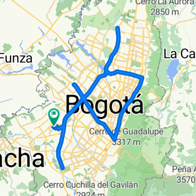
Laburo Vuelta
A cycling route starting in Bogotá, Bogota D.C., Colombia.
Overview
About this route
Connecta street 26 - Villas de Granada
- -:--
- Duration
- 4.2 km
- Distance
- 13 m
- Ascent
- 14 m
- Descent
- ---
- Avg. speed
- ---
- Max. altitude

Route quality
Waytypes & surfaces along the route
Waytypes
Quiet road
1.2 km
(28 %)
Road
1 km
(23 %)
Surfaces
Paved
3.8 km
(90 %)
Asphalt
3.2 km
(76 %)
Concrete
0.6 km
(14 %)
Undefined
0.4 km
(10 %)
Continue with Bikemap
Use, edit, or download this cycling route
You would like to ride Laburo Vuelta or customize it for your own trip? Here is what you can do with this Bikemap route:
Free features
- Save this route as favorite or in collections
- Copy & plan your own version of this route
- Sync your route with Garmin or Wahoo
Premium features
Free trial for 3 days, or one-time payment. More about Bikemap Premium.
- Navigate this route on iOS & Android
- Export a GPX / KML file of this route
- Create your custom printout (try it for free)
- Download this route for offline navigation
Discover more Premium features.
Get Bikemap PremiumFrom our community
Other popular routes starting in Bogotá
 De Carrera 19 # 7-19, Bogotá, D.C. a Calle 11 Sur 25-58, Bogotá
- Distance
- 45.1 km
- Ascent
- 809 m
- Descent
- 854 m
- Location
- Bogotá, Bogota D.C., Colombia
 Calle Sur # 78Q-5 to Carrera 78l # 33A-62
- Distance
- 76.8 km
- Ascent
- 225 m
- Descent
- 246 m
- Location
- Bogotá, Bogota D.C., Colombia
 la calera de domingo
- Distance
- 22.5 km
- Ascent
- 555 m
- Descent
- 285 m
- Location
- Bogotá, Bogota D.C., Colombia
 De Calle 6f 1A-28 a Avenida Carrera # 116-4
- Distance
- 14.1 km
- Ascent
- 264 m
- Descent
- 350 m
- Location
- Bogotá, Bogota D.C., Colombia
 De Calle 57 Sur 15-70, Bogotá a Diagonal 40 14, Soacha
- Distance
- 23.5 km
- Ascent
- 630 m
- Descent
- 624 m
- Location
- Bogotá, Bogota D.C., Colombia
 Colegio Ela
- Distance
- 9.4 km
- Ascent
- 34 m
- Descent
- 44 m
- Location
- Bogotá, Bogota D.C., Colombia
 Carrera 72B, Bogotá to Calle 23D, Bogotá
- Distance
- 24.3 km
- Ascent
- 163 m
- Descent
- 160 m
- Location
- Bogotá, Bogota D.C., Colombia
 25 de mayo 6:05 a. m.
- Distance
- 18.3 km
- Ascent
- 42 m
- Descent
- 49 m
- Location
- Bogotá, Bogota D.C., Colombia
Open it in the app