

Witten-Essen-Witten
A cycling route starting in Witten, North Rhine-Westphalia, Germany.
Overview
About this route
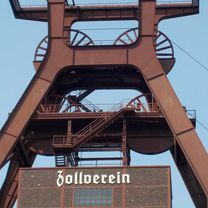
Via Bo and Wat to Zollverein. Along Rheinische Bahn and Grugaweg to the Ruhr. On the RTR following the Ruhr upstream to Bommern.
- -:--
- Duration
- 93.8 km
- Distance
- 272 m
- Ascent
- 272 m
- Descent
- ---
- Avg. speed
- ---
- Max. altitude
Route photos


Route quality
Waytypes & surfaces along the route
Waytypes
Path
49.7 km
(53 %)
Quiet road
19.7 km
(21 %)
Surfaces
Paved
74.1 km
(79 %)
Unpaved
14.1 km
(15 %)
Asphalt
72.3 km
(77 %)
Gravel
11.3 km
(12 %)
Continue with Bikemap
Use, edit, or download this cycling route
You would like to ride Witten-Essen-Witten or customize it for your own trip? Here is what you can do with this Bikemap route:
Free features
- Save this route as favorite or in collections
- Copy & plan your own version of this route
- Split it into stages to create a multi-day tour
- Sync your route with Garmin or Wahoo
Premium features
Free trial for 3 days, or one-time payment. More about Bikemap Premium.
- Navigate this route on iOS & Android
- Export a GPX / KML file of this route
- Create your custom printout (try it for free)
- Download this route for offline navigation
Discover more Premium features.
Get Bikemap PremiumFrom our community
Other popular routes starting in Witten
 Witten-Hohenstein
- Distance
- 13.3 km
- Ascent
- 277 m
- Descent
- 277 m
- Location
- Witten, North Rhine-Westphalia, Germany
 Mittlere Route Langendreer - Stockum
- Distance
- 11.4 km
- Ascent
- 91 m
- Descent
- 85 m
- Location
- Witten, North Rhine-Westphalia, Germany
 Hohensyburg
- Distance
- 33.7 km
- Ascent
- 517 m
- Descent
- 517 m
- Location
- Witten, North Rhine-Westphalia, Germany
 ketteimmerrechts.de // kir-ig.de
- Distance
- 49.7 km
- Ascent
- 455 m
- Descent
- 458 m
- Location
- Witten, North Rhine-Westphalia, Germany
 Rheinischer Esel, Witten nach Im Hölken 34, Sprockhövel
- Distance
- 13.7 km
- Ascent
- 230 m
- Descent
- 113 m
- Location
- Witten, North Rhine-Westphalia, Germany
 Witten-Essen-Witten
- Distance
- 93.8 km
- Ascent
- 272 m
- Descent
- 272 m
- Location
- Witten, North Rhine-Westphalia, Germany
 Wittener RTF 2008 71er
- Distance
- 70.2 km
- Ascent
- 662 m
- Descent
- 628 m
- Location
- Witten, North Rhine-Westphalia, Germany
 Kleine Ruhrrunde
- Distance
- 52.5 km
- Ascent
- 350 m
- Descent
- 362 m
- Location
- Witten, North Rhine-Westphalia, Germany
Open it in the app