
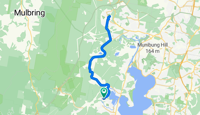
Blackalls Park Public School to West Wallsend Swimming Centre
A cycling route starting in Fennell Bay, New South Wales, Australia.
Overview
About this route
Blackalls Park Public School to West Wallsend Swimming Centre (and return)
-
Leave Blackalls Park PS entrance at cnr Todd and Rupert Streets. travelling NE on Rupert.
-
Turn LEFT onto the MAIN ROAD (Fassifern Street) and travel about 1300m (past Fassifern Railway Station and UNDER the viaduct) until you reach Fassifern Public School road crossing.
-
Turn LEFT into Miller Road and proceed to the intersection with Wakefield Road ... approximately 4.9km.
-
Turn RIGHT onto Wakefield Road, the Main Road to West Wallsend from here.
-
Stay on Wakefield Road to travel the next 4.65km to the Barnsley roundabout.
-
Travel "straight ahead" through the roundabout onto Appletree Road for 2.6km through Holmesville and past West Wallsend High School. You will arrive at Withers Street.
6. TURN LEFT onto Withers Street and travel NORTH just 230 metres downhill to the intersection with Edden Street.
-
Turn RIGHT into Edden Street. The West Wallsend Swimming Centre is about 200 metres EAST from the intersection.
-
Once your swim/visit is complete, you can retrace your route home by reversing these instructions.
- -:--
- Duration
- 29.3 km
- Distance
- 341 m
- Ascent
- 341 m
- Descent
- ---
- Avg. speed
- ---
- Max. altitude

Route quality
Waytypes & surfaces along the route
Waytypes
Busy road
28 km
(96 %)
Quiet road
1.2 km
(4 %)
Surfaces
Paved
29.2 km
(100 %)
Asphalt
28.7 km
(98 %)
Paved (undefined)
0.5 km
(2 %)
Undefined
0.1 km
(<1 %)
Continue with Bikemap
Use, edit, or download this cycling route
You would like to ride Blackalls Park Public School to West Wallsend Swimming Centre or customize it for your own trip? Here is what you can do with this Bikemap route:
Free features
- Save this route as favorite or in collections
- Copy & plan your own version of this route
- Sync your route with Garmin or Wahoo
Premium features
Free trial for 3 days, or one-time payment. More about Bikemap Premium.
- Navigate this route on iOS & Android
- Export a GPX / KML file of this route
- Create your custom printout (try it for free)
- Download this route for offline navigation
Discover more Premium features.
Get Bikemap PremiumFrom our community
Other popular routes starting in Fennell Bay
 Around Fennell Bay & connected suburbs
- Distance
- 13.2 km
- Ascent
- 82 m
- Descent
- 94 m
- Location
- Fennell Bay, New South Wales, Australia
 BPPS to Freemans Waterhole Subway
- Distance
- 28.6 km
- Ascent
- 197 m
- Descent
- 197 m
- Location
- Fennell Bay, New South Wales, Australia
 Lapped Fennell Bay & Edmunds Bay + Toronto Shops
- Distance
- 11.2 km
- Ascent
- 87 m
- Descent
- 85 m
- Location
- Fennell Bay, New South Wales, Australia
 13.5km plus Suburban Run
- Distance
- 14.2 km
- Ascent
- 80 m
- Descent
- 83 m
- Location
- Fennell Bay, New South Wales, Australia
 Blackalls Park Public School to Toronto Pool +
- Distance
- 10.5 km
- Ascent
- 67 m
- Descent
- 66 m
- Location
- Fennell Bay, New South Wales, Australia
 Blackalls Park to North Toronto Industrial Estate then home through Fassifern
- Distance
- 8.5 km
- Ascent
- 74 m
- Descent
- 48 m
- Location
- Fennell Bay, New South Wales, Australia
 Toronto Pool (short) + Back Home (long)
- Distance
- 12.1 km
- Ascent
- 109 m
- Descent
- 106 m
- Location
- Fennell Bay, New South Wales, Australia
 Toronto High School, Coles, home
- Distance
- 16.7 km
- Ascent
- 84 m
- Descent
- 88 m
- Location
- Fennell Bay, New South Wales, Australia
Open it in the app