

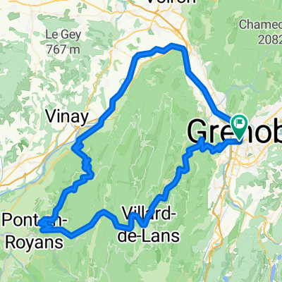
Grenoble-Montpellier
A cycling route starting in Grenoble, Auvergne-Rhône-Alpes, France.
Overview
About this route
Grenoble-Montpellier
- -:--
- Duration
- 408.3 km
- Distance
- 1,701 m
- Ascent
- 1,905 m
- Descent
- ---
- Avg. speed
- ---
- Max. altitude
Route quality
Waytypes & surfaces along the route
Waytypes
Road
114.3 km
(28 %)
Quiet road
110.2 km
(27 %)
Surfaces
Paved
249 km
(61 %)
Unpaved
24.5 km
(6 %)
Asphalt
245 km
(60 %)
Gravel
12.2 km
(3 %)
Route highlights
Points of interest along the route
Point of interest after 64.8 km
Primera noche
Point of interest after 104.3 km
Legar a comer el 2º día
Point of interest after 143.5 km
2º Noche
Point of interest after 207.8 km
Comida 3º día
Point of interest after 295.2 km
3º noche
Point of interest after 313 km
Pasar la mañana y pedalear por la tarde
Point of interest after 366 km
4º noche
Continue with Bikemap
Use, edit, or download this cycling route
You would like to ride Grenoble-Montpellier or customize it for your own trip? Here is what you can do with this Bikemap route:
Free features
- Save this route as favorite or in collections
- Copy & plan your own version of this route
- Split it into stages to create a multi-day tour
- Sync your route with Garmin or Wahoo
Premium features
Free trial for 3 days, or one-time payment. More about Bikemap Premium.
- Navigate this route on iOS & Android
- Export a GPX / KML file of this route
- Create your custom printout (try it for free)
- Download this route for offline navigation
Discover more Premium features.
Get Bikemap PremiumFrom our community
Other popular routes starting in Grenoble
 Day 3 - Grenoble to Saint-Pierre-d'Argençon
- Distance
- 99.6 km
- Ascent
- 1,451 m
- Descent
- 883 m
- Location
- Grenoble, Auvergne-Rhône-Alpes, France
 Grenoble to Saint Gervais
- Distance
- 76.9 km
- Ascent
- 58 m
- Descent
- 60 m
- Location
- Grenoble, Auvergne-Rhône-Alpes, France
 grenoble - cognin-les-gorges
- Distance
- 123.1 km
- Ascent
- 2,095 m
- Descent
- 2,100 m
- Location
- Grenoble, Auvergne-Rhône-Alpes, France
 Chamrousse
- Distance
- 64.8 km
- Ascent
- 1,555 m
- Descent
- 1,555 m
- Location
- Grenoble, Auvergne-Rhône-Alpes, France
 col de la Placette depuis Grenoble
- Distance
- 63.9 km
- Ascent
- 493 m
- Descent
- 494 m
- Location
- Grenoble, Auvergne-Rhône-Alpes, France
 5 March 23, Saint Laurent (with Ste)
- Distance
- 7.4 km
- Ascent
- 40 m
- Descent
- 42 m
- Location
- Grenoble, Auvergne-Rhône-Alpes, France
 France - Grenoble - Col de la Placette
- Distance
- 61.5 km
- Ascent
- 502 m
- Descent
- 505 m
- Location
- Grenoble, Auvergne-Rhône-Alpes, France
 Chartreuse - Col de Porte et col du Coq
- Distance
- 70.2 km
- Ascent
- 1,813 m
- Descent
- 1,814 m
- Location
- Grenoble, Auvergne-Rhône-Alpes, France
Open it in the app