

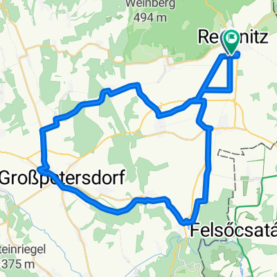
Rohonc-Óhodász-Szalónak
A cycling route starting in Rechnitz, Burgenland, Austria.
Overview
About this route
- -:--
- Duration
- 38.8 km
- Distance
- 511 m
- Ascent
- 511 m
- Descent
- ---
- Avg. speed
- ---
- Max. altitude

Route quality
Waytypes & surfaces along the route
Waytypes
Road
12.4 km
(32 %)
Quiet road
2.3 km
(6 %)
Surfaces
Paved
7.8 km
(20 %)
Unpaved
2.7 km
(7 %)
Asphalt
7.8 km
(20 %)
Unpaved (undefined)
1.9 km
(5 %)
Continue with Bikemap
Use, edit, or download this cycling route
You would like to ride Rohonc-Óhodász-Szalónak or customize it for your own trip? Here is what you can do with this Bikemap route:
Free features
- Save this route as favorite or in collections
- Copy & plan your own version of this route
- Sync your route with Garmin or Wahoo
Premium features
Free trial for 3 days, or one-time payment. More about Bikemap Premium.
- Navigate this route on iOS & Android
- Export a GPX / KML file of this route
- Create your custom printout (try it for free)
- Download this route for offline navigation
Discover more Premium features.
Get Bikemap PremiumFrom our community
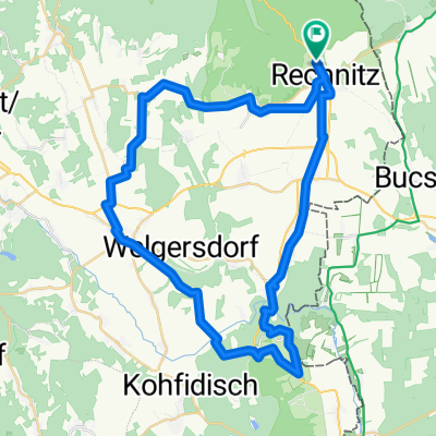
Other popular routes starting in Rechnitz
 Blumengasse nach Blumengasse
- Distance
- 39.2 km
- Ascent
- 305 m
- Descent
- 307 m
- Location
- Rechnitz, Burgenland, Austria
 Rechnitz Eisenberg Großpetersdorf Rechnitz
- Distance
- 44.5 km
- Ascent
- 527 m
- Descent
- 530 m
- Location
- Rechnitz, Burgenland, Austria
 56, Rechnitz nach Hauptplatz, Stinatz
- Distance
- 34.5 km
- Ascent
- 492 m
- Descent
- 499 m
- Location
- Rechnitz, Burgenland, Austria
 Faludigasse 26–28, Rechnitz nach Faludigasse 26–28, Rechnitz
- Distance
- 18.3 km
- Ascent
- 657 m
- Descent
- 657 m
- Location
- Rechnitz, Burgenland, Austria
 Rechnitz Eisenberg Großpetersdorf Rechnitz
- Distance
- 51.6 km
- Ascent
- 720 m
- Descent
- 683 m
- Location
- Rechnitz, Burgenland, Austria
 Naturpark Trail Runde
- Distance
- 26.7 km
- Ascent
- 769 m
- Descent
- 766 m
- Location
- Rechnitz, Burgenland, Austria
 Sommertour 2025 Tag 3
- Distance
- 63.9 km
- Ascent
- 692 m
- Descent
- 702 m
- Location
- Rechnitz, Burgenland, Austria
 Bahntrassen-Radweg
- Distance
- 41.3 km
- Ascent
- 269 m
- Descent
- 211 m
- Location
- Rechnitz, Burgenland, Austria
Open it in the app