

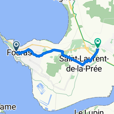
La Rochelle Pointe Fouras
A cycling route starting in Fouras, Nouvelle-Aquitaine, France.
Overview
About this route
Projet de circuit velo Pique-nique à la pointe Fouras en partant de La Rochelle Le retour se faisant par le littoral en empruntant une partie de la vie verte "EV8 "
- -:--
- Duration
- 78.4 km
- Distance
- 55 m
- Ascent
- 53 m
- Descent
- ---
- Avg. speed
- ---
- Max. altitude

Route quality
Waytypes & surfaces along the route
Waytypes
Quiet road
25.7 km
(33 %)
Road
25.4 km
(32 %)
Surfaces
Paved
48.9 km
(62 %)
Unpaved
7.3 km
(9 %)
Asphalt
46.4 km
(59 %)
Gravel
7.3 km
(9 %)
Continue with Bikemap
Use, edit, or download this cycling route
You would like to ride La Rochelle Pointe Fouras or customize it for your own trip? Here is what you can do with this Bikemap route:
Free features
- Save this route as favorite or in collections
- Copy & plan your own version of this route
- Sync your route with Garmin or Wahoo
Premium features
Free trial for 3 days, or one-time payment. More about Bikemap Premium.
- Navigate this route on iOS & Android
- Export a GPX / KML file of this route
- Create your custom printout (try it for free)
- Download this route for offline navigation
Discover more Premium features.
Get Bikemap PremiumFrom our community
Other popular routes starting in Fouras
 2 Oct - Fouras to La Palmyre
- Distance
- 106.1 km
- Ascent
- 82 m
- Descent
- 77 m
- Location
- Fouras, Nouvelle-Aquitaine, France
 La Rochelle Pointe Fouras
- Distance
- 78.4 km
- Ascent
- 55 m
- Descent
- 53 m
- Location
- Fouras, Nouvelle-Aquitaine, France
 Schiereiland Fouras-Pointe de la Fuméé
- Distance
- 22.4 km
- Ascent
- 39 m
- Descent
- 39 m
- Location
- Fouras, Nouvelle-Aquitaine, France
 Day 28 Fouras to La Rochelle
- Distance
- 40.5 km
- Ascent
- 43 m
- Descent
- 48 m
- Location
- Fouras, Nouvelle-Aquitaine, France
 gare de fouras
- Distance
- 7.2 km
- Ascent
- 22 m
- Descent
- 20 m
- Location
- Fouras, Nouvelle-Aquitaine, France
 EuskalRide#J3
- Distance
- 182 km
- Ascent
- 174 m
- Descent
- 166 m
- Location
- Fouras, Nouvelle-Aquitaine, France
 De 50 Rue du Bois Vert, Fouras à Avenue du Général de Gaulle, La Rochelle
- Distance
- 29.7 km
- Ascent
- 12 m
- Descent
- 23 m
- Location
- Fouras, Nouvelle-Aquitaine, France
 20180819 - Ile d'Aix-Rochefort
- Distance
- 22.3 km
- Ascent
- 57 m
- Descent
- 53 m
- Location
- Fouras, Nouvelle-Aquitaine, France
Open it in the app