

Slowenien, Istrien
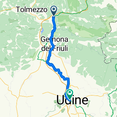
A cycling route starting in Amaro, Friuli Venezia Giulia, Italy.
Overview
About this route
- -:--
- Duration
- 531.7 km
- Distance
- 2,776 m
- Ascent
- 2,720 m
- Descent
- ---
- Avg. speed
- ---
- Max. altitude

Route quality
Waytypes & surfaces along the route
Waytypes
Busy road
240.6 km
(45 %)
Quiet road
139 km
(26 %)
Surfaces
Paved
372.2 km
(70 %)
Unpaved
26.7 km
(5 %)
Asphalt
366.1 km
(69 %)
Gravel
13.8 km
(3 %)
Route highlights
Points of interest along the route
Point of interest after 9.4 km
Camping
Point of interest after 11.7 km
Camping
Point of interest after 112.5 km
Camping
Point of interest after 114.8 km
Camping
Point of interest after 138 km
Camping
Point of interest after 142.6 km
Camping
Point of interest after 159.5 km
Camping
Point of interest after 165.4 km
Camping
Point of interest after 184.2 km
Camping
Point of interest after 197.4 km
Mehrere Camping
Point of interest after 233.4 km
Camping
Point of interest after 264.1 km
Camping
Point of interest after 278.4 km
Camping
Point of interest after 310.8 km
Camping
Point of interest after 315.5 km
3 Camping
Point of interest after 320 km
Camping
Point of interest after 327.3 km
Camping
Point of interest after 382.6 km
Camping
Point of interest after 467.7 km
Camping
Point of interest after 472.2 km
Camping
Point of interest after 473.8 km
Camping
Point of interest after 485.6 km
Camping
Point of interest after 486.4 km
Camping
Point of interest after 491.1 km
Camping
Continue with Bikemap
Use, edit, or download this cycling route
You would like to ride Slowenien, Istrien or customize it for your own trip? Here is what you can do with this Bikemap route:
Free features
- Save this route as favorite or in collections
- Copy & plan your own version of this route
- Split it into stages to create a multi-day tour
- Sync your route with Garmin or Wahoo
Premium features
Free trial for 3 days, or one-time payment. More about Bikemap Premium.
- Navigate this route on iOS & Android
- Export a GPX / KML file of this route
- Create your custom printout (try it for free)
- Download this route for offline navigation
Discover more Premium features.
Get Bikemap PremiumFrom our community
Other popular routes starting in Amaro
 7. Etappe: von Venzone (il carnia) nach Udine (Friuli)
- Distance
- 59.5 km
- Ascent
- 322 m
- Descent
- 478 m
- Location
- Amaro, Friuli Venezia Giulia, Italy
 Friaul Slowenien
- Distance
- 190.2 km
- Ascent
- 1,337 m
- Descent
- 1,334 m
- Location
- Amaro, Friuli Venezia Giulia, Italy
 Tag 5 - von Carnia nach Udine
- Distance
- 49.8 km
- Ascent
- 176 m
- Descent
- 326 m
- Location
- Amaro, Friuli Venezia Giulia, Italy
 Carnia-Monte Croce-Venzone
- Distance
- 97 km
- Ascent
- 1,487 m
- Descent
- 1,558 m
- Location
- Amaro, Friuli Venezia Giulia, Italy
 2022-05-23 Carnia - Udine
- Distance
- 51.7 km
- Ascent
- 233 m
- Descent
- 386 m
- Location
- Amaro, Friuli Venezia Giulia, Italy
 Slowenien, Istrien
- Distance
- 531.7 km
- Ascent
- 2,776 m
- Descent
- 2,720 m
- Location
- Amaro, Friuli Venezia Giulia, Italy
 3./2 Carnia del Friuli-Udine 2021-09-21
- Distance
- 51 km
- Ascent
- 201 m
- Descent
- 360 m
- Location
- Amaro, Friuli Venezia Giulia, Italy
 Variante su itinerario Tolmezzo _ Amaro_Tolmezzo
- Distance
- 4.3 km
- Ascent
- 31 m
- Descent
- 77 m
- Location
- Amaro, Friuli Venezia Giulia, Italy
Open it in the app