

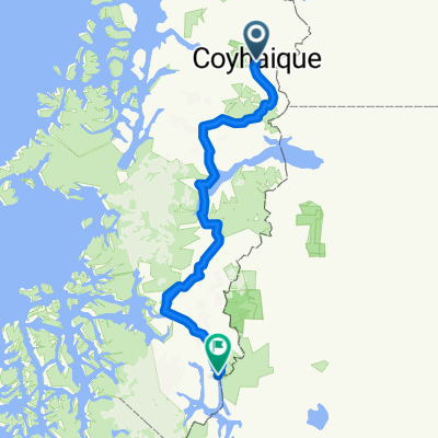
Paseo lento en Coyhaique
A cycling route starting in Coyhaique, Aysén, Chile.
Overview
About this route
- 32 min
- Duration
- 2.3 km
- Distance
- 108 m
- Ascent
- 64 m
- Descent
- 4.2 km/h
- Avg. speed
- ---
- Max. altitude

Route photos


Continue with Bikemap
Use, edit, or download this cycling route
You would like to ride Paseo lento en Coyhaique or customize it for your own trip? Here is what you can do with this Bikemap route:
Free features
- Save this route as favorite or in collections
- Copy & plan your own version of this route
- Sync your route with Garmin or Wahoo
Premium features
Free trial for 3 days, or one-time payment. More about Bikemap Premium.
- Navigate this route on iOS & Android
- Export a GPX / KML file of this route
- Create your custom printout (try it for free)
- Download this route for offline navigation
Discover more Premium features.
Get Bikemap PremiumFrom our community
Other popular routes starting in Coyhaique
 Carretera 4
- Distance
- 263.7 km
- Ascent
- 2,794 m
- Descent
- 2,603 m
- Location
- Coyhaique, Aysén, Chile
 Descenso del Cerro Castillo
- Distance
- 161.5 km
- Ascent
- 1,859 m
- Descent
- 1,920 m
- Location
- Coyhaique, Aysén, Chile
 Carretera Austral - Tappa 14
- Distance
- 55.2 km
- Ascent
- 687 m
- Descent
- 450 m
- Location
- Coyhaique, Aysén, Chile
 Day 54/55/56/57: Coyhaique to Puyuhuapi
- Distance
- 220.5 km
- Ascent
- 1,535 m
- Descent
- 1,800 m
- Location
- Coyhaique, Aysén, Chile
 Coyhaique to Chacabuco
- Distance
- 82.8 km
- Ascent
- 589 m
- Descent
- 868 m
- Location
- Coyhaique, Aysén, Chile
 Coihaique - Villa OHiggins
- Distance
- 621.3 km
- Ascent
- 3,297 m
- Descent
- 3,302 m
- Location
- Coyhaique, Aysén, Chile
 Carretera Austral Cochrane - La Junta 280km
- Distance
- 279.8 km
- Ascent
- 1,416 m
- Descent
- 1,660 m
- Location
- Coyhaique, Aysén, Chile
 Paseo lento en Coyhaique
- Distance
- 2.3 km
- Ascent
- 108 m
- Descent
- 64 m
- Location
- Coyhaique, Aysén, Chile
Open it in the app