

Overview
About this route
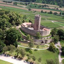
Hotel Kraichtaler Hof, Unteröwisheim
- -:--
- Duration
- 91.4 km
- Distance
- 406 m
- Ascent
- 475 m
- Descent
- ---
- Avg. speed
- ---
- Max. altitude

Part of
2019 Kraichgau
4 stages
Route quality
Waytypes & surfaces along the route
Waytypes
Track
17.4 km
(19 %)
Quiet road
16.5 km
(18 %)
Surfaces
Paved
79.5 km
(87 %)
Unpaved
4.6 km
(5 %)
Asphalt
76.8 km
(84 %)
Concrete
1.8 km
(2 %)
Continue with Bikemap
Use, edit, or download this cycling route
You would like to ride T3 Kraichgau or customize it for your own trip? Here is what you can do with this Bikemap route:
Free features
- Save this route as favorite or in collections
- Copy & plan your own version of this route
- Split it into stages to create a multi-day tour
- Sync your route with Garmin or Wahoo
Premium features
Free trial for 3 days, or one-time payment. More about Bikemap Premium.
- Navigate this route on iOS & Android
- Export a GPX / KML file of this route
- Create your custom printout (try it for free)
- Download this route for offline navigation
Discover more Premium features.
Get Bikemap PremiumFrom our community
Other popular routes starting in Michelstadt
 1.1 Tour klinge Odenwald Tour Alternative (83km)
- Distance
- 84.6 km
- Ascent
- 803 m
- Descent
- 802 m
- Location
- Michelstadt, Hesse, Germany
 Zeller Kopf
- Distance
- 16.1 km
- Ascent
- 334 m
- Descent
- 338 m
- Location
- Michelstadt, Hesse, Germany
 Frühjahrsroute
- Distance
- 39.5 km
- Ascent
- 499 m
- Descent
- 498 m
- Location
- Michelstadt, Hesse, Germany
 Mossautal-Runde
- Distance
- 46.6 km
- Ascent
- 935 m
- Descent
- 792 m
- Location
- Michelstadt, Hesse, Germany
 Michelstadt-Neckar-Rothenberg-Michelstadt
- Distance
- 71.4 km
- Ascent
- 636 m
- Descent
- 634 m
- Location
- Michelstadt, Hesse, Germany
 T3 Kraichgau
- Distance
- 91.4 km
- Ascent
- 406 m
- Descent
- 475 m
- Location
- Michelstadt, Hesse, Germany
 Odenwald Tour 2 aus Tour-Magazin
- Distance
- 99.7 km
- Ascent
- 1,074 m
- Descent
- 1,074 m
- Location
- Michelstadt, Hesse, Germany
 50km Odenwald
- Distance
- 50.5 km
- Ascent
- 716 m
- Descent
- 662 m
- Location
- Michelstadt, Hesse, Germany
Open it in the app