

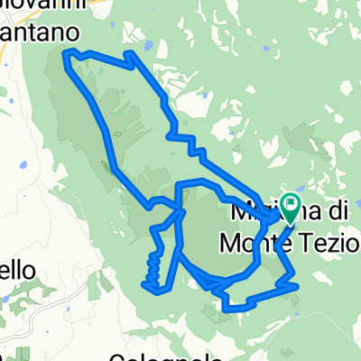
Monte Tezio
A cycling route starting in Ponte Pattoli, Umbria, Italy.
Overview
About this route
- -:--
- Duration
- 40.8 km
- Distance
- 1,025 m
- Ascent
- 1,025 m
- Descent
- ---
- Avg. speed
- ---
- Max. altitude

Continue with Bikemap
Use, edit, or download this cycling route
You would like to ride Monte Tezio or customize it for your own trip? Here is what you can do with this Bikemap route:
Free features
- Save this route as favorite or in collections
- Copy & plan your own version of this route
- Sync your route with Garmin or Wahoo
Premium features
Free trial for 3 days, or one-time payment. More about Bikemap Premium.
- Navigate this route on iOS & Android
- Export a GPX / KML file of this route
- Create your custom printout (try it for free)
- Download this route for offline navigation
Discover more Premium features.
Get Bikemap PremiumFrom our community
Other popular routes starting in Ponte Pattoli
 GIRO DEL LAGO PER POZZUOLO
- Distance
- 123.1 km
- Ascent
- 1,699 m
- Descent
- 1,700 m
- Location
- Ponte Pattoli, Umbria, Italy
 5 castelli
- Distance
- 24.8 km
- Ascent
- 493 m
- Descent
- 533 m
- Location
- Ponte Pattoli, Umbria, Italy
 Da Strada Castiglione Ugolino, Perugia a Via Madonna del Giglio 56, Umbertide
- Distance
- 17.4 km
- Ascent
- 459 m
- Descent
- 456 m
- Location
- Ponte Pattoli, Umbria, Italy
 bruna
bruna- Distance
- 6.7 km
- Ascent
- 319 m
- Descent
- 322 m
- Location
- Ponte Pattoli, Umbria, Italy
 umbertide2
- Distance
- 71.3 km
- Ascent
- 1,037 m
- Descent
- 1,050 m
- Location
- Ponte Pattoli, Umbria, Italy
 monte tezio all mountain
- Distance
- 22.3 km
- Ascent
- 1,051 m
- Descent
- 1,054 m
- Location
- Ponte Pattoli, Umbria, Italy
 magnata de pesce
- Distance
- 172.3 km
- Ascent
- 1,011 m
- Descent
- 1,215 m
- Location
- Ponte Pattoli, Umbria, Italy
 Monte Tezio
- Distance
- 40.8 km
- Ascent
- 1,025 m
- Descent
- 1,025 m
- Location
- Ponte Pattoli, Umbria, Italy
Open it in the app