

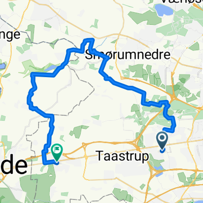
Strade Negro III
A cycling route starting in Albertslund, Capital Region, Denmark.
Overview
About this route
Brosten på Taastrup Hovedgade, to gange over Hersted Høje samt de hårde områder omkring Veksø, Ganløse, Værløse og Smørrumnederen.
- -:--
- Duration
- 112.8 km
- Distance
- 199 m
- Ascent
- 200 m
- Descent
- ---
- Avg. speed
- ---
- Max. altitude

Route quality
Waytypes & surfaces along the route
Waytypes
Road
42.9 km
(38 %)
Cycleway
28.2 km
(25 %)
Surfaces
Paved
99.2 km
(88 %)
Unpaved
9 km
(8 %)
Asphalt
98.1 km
(87 %)
Gravel
6.8 km
(6 %)
Continue with Bikemap
Use, edit, or download this cycling route
You would like to ride Strade Negro III or customize it for your own trip? Here is what you can do with this Bikemap route:
Free features
- Save this route as favorite or in collections
- Copy & plan your own version of this route
- Split it into stages to create a multi-day tour
- Sync your route with Garmin or Wahoo
Premium features
Free trial for 3 days, or one-time payment. More about Bikemap Premium.
- Navigate this route on iOS & Android
- Export a GPX / KML file of this route
- Create your custom printout (try it for free)
- Download this route for offline navigation
Discover more Premium features.
Get Bikemap PremiumFrom our community
Other popular routes starting in Albertslund
 Risby/Rødovre route 199
- Distance
- 33.1 km
- Ascent
- 75 m
- Descent
- 84 m
- Location
- Albertslund, Capital Region, Denmark
 Gravel på Vestegnen
- Distance
- 65.9 km
- Ascent
- 123 m
- Descent
- 123 m
- Location
- Albertslund, Capital Region, Denmark
 sommertur mod ur
- Distance
- 947.9 km
- Ascent
- 490 m
- Descent
- 490 m
- Location
- Albertslund, Capital Region, Denmark
 Vestskoven Vest-3
- Distance
- 39.8 km
- Ascent
- 150 m
- Descent
- 131 m
- Location
- Albertslund, Capital Region, Denmark
 En lille hyggetur
- Distance
- 58.5 km
- Ascent
- 135 m
- Descent
- 135 m
- Location
- Albertslund, Capital Region, Denmark
 Galgebakken Torv, Albertslund to Galgebakken Sten, Albertslund
- Distance
- 26.8 km
- Ascent
- 68 m
- Descent
- 68 m
- Location
- Albertslund, Capital Region, Denmark
 Sengeløse route
- Distance
- 38.9 km
- Ascent
- 110 m
- Descent
- 110 m
- Location
- Albertslund, Capital Region, Denmark
 Albertslund-Gundslille (circle)
- Distance
- 40.9 km
- Ascent
- 113 m
- Descent
- 110 m
- Location
- Albertslund, Capital Region, Denmark
Open it in the app