

Krynica-Jaworzyna-Krynica
A cycling route starting in Krynica-Zdrój, Lesser Poland Voivodeship, Poland.
Overview
About this route
bardzo ładna trasa, możliwośc skorzystaniaz wyciągu(my tak uczyniliśmy:) 10zł osoba +bike. Troszeczkę zboczyliśmy z niebieskiego szlaku i zjeżdzaliśmhy w dość cięzkich warunkach terenowych. Ogólnie polecam.
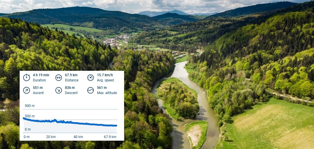
- -:--
- Duration
- 30.7 km
- Distance
- 933 m
- Ascent
- 951 m
- Descent
- ---
- Avg. speed
- ---
- Avg. speed
Continue with Bikemap
Use, edit, or download this cycling route
You would like to ride Krynica-Jaworzyna-Krynica or customize it for your own trip? Here is what you can do with this Bikemap route:
Free features
- Save this route as favorite or in collections
- Copy & plan your own version of this route
- Sync your route with Garmin or Wahoo
Premium features
Free trial for 3 days, or one-time payment. More about Bikemap Premium.
- Navigate this route on iOS & Android
- Export a GPX / KML file of this route
- Create your custom printout (try it for free)
- Download this route for offline navigation
Discover more Premium features.
Get Bikemap PremiumFrom our community
Other popular routes starting in Krynica-Zdrój
 Z Beskidu Sądeckiego w Beskid Niski z przyczepką
- Distance
- 31.4 km
- Ascent
- 679 m
- Descent
- 679 m
- Location
- Krynica-Zdrój, Lesser Poland Voivodeship, Poland
 Krynica Zdrój do Nowego Sącza
- Distance
- 71.3 km
- Ascent
- 621 m
- Descent
- 901 m
- Location
- Krynica-Zdrój, Lesser Poland Voivodeship, Poland
 Krynica - Muszyna - Krynica - 14 sierpnia, 10:25
- Distance
- 29 km
- Ascent
- 191 m
- Descent
- 221 m
- Location
- Krynica-Zdrój, Lesser Poland Voivodeship, Poland
 Kazimierza Pułaskiego 116–124, Krynica-Zdrój do Kazimierza Pułaskiego 116–124, Krynica-Zdrój
- Distance
- 32.7 km
- Ascent
- 586 m
- Descent
- 592 m
- Location
- Krynica-Zdrój, Lesser Poland Voivodeship, Poland
 Pasmo Jaworzyny: Krynica-Jaworzyna-Runek-Hala Łabowska-Makowica-Nowy Sącz
- Distance
- 44.1 km
- Ascent
- 692 m
- Descent
- 1,037 m
- Location
- Krynica-Zdrój, Lesser Poland Voivodeship, Poland
 Majka Days - dystans długi
- Distance
- 74.5 km
- Ascent
- 954 m
- Descent
- 768 m
- Location
- Krynica-Zdrój, Lesser Poland Voivodeship, Poland
 Śladami maratonów MTB *** Krynica MTB giga (cut)
- Distance
- 27.8 km
- Ascent
- 841 m
- Descent
- 841 m
- Location
- Krynica-Zdrój, Lesser Poland Voivodeship, Poland
 Czarny Potok_Jaworzyna Krynicka_Runek_Hala Łabowska_Łomnica Zdrój_Wierchomla WIelka_Muszyna_Krynica_Czarny Potok
- Distance
- 64.3 km
- Ascent
- 955 m
- Descent
- 959 m
- Location
- Krynica-Zdrój, Lesser Poland Voivodeship, Poland
Open it in the app