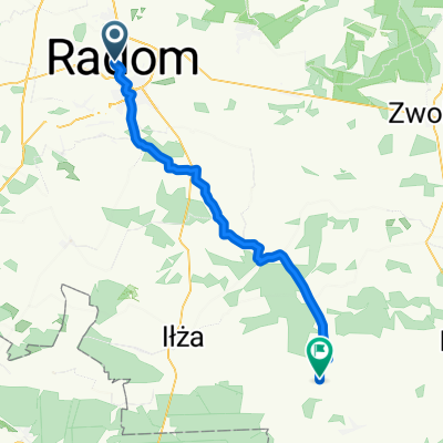
Radom- JEdlnia Let
A cycling route starting in Radom, Masovian Voivodeship, Poland.
Overview
About this route
The route is already partially on the terrain. With sand and stones.
- -:--
- Duration
- 11.7 km
- Distance
- 16 m
- Ascent
- 32 m
- Descent
- ---
- Avg. speed
- ---
- Max. altitude
Continue with Bikemap
Use, edit, or download this cycling route
You would like to ride Radom- JEdlnia Let or customize it for your own trip? Here is what you can do with this Bikemap route:
Free features
- Save this route as favorite or in collections
- Copy & plan your own version of this route
- Sync your route with Garmin or Wahoo
Premium features
Free trial for 3 days, or one-time payment. More about Bikemap Premium.
- Navigate this route on iOS & Android
- Export a GPX / KML file of this route
- Create your custom printout (try it for free)
- Download this route for offline navigation
Discover more Premium features.
Get Bikemap PremiumFrom our community
Other popular routes starting in Radom
- Radom i Puszcza Kozienicka
- Distance
- 60 km
- Ascent
- 0 m
- Descent
- 0 m
- Location
- Radom, Masovian Voivodeship, Poland
- Radom - Grzybowa G贸ra i powr贸t przez Skaryszew
- Distance
- 101.3 km
- Ascent
- 257 m
- Descent
- 256 m
- Location
- Radom, Masovian Voivodeship, Poland
- Radom - Grzybowa G贸ra z ma艂ym ok艂adem
- Distance
- 152.8 km
- Ascent
- 422 m
- Descent
- 421 m
- Location
- Radom, Masovian Voivodeship, Poland
- Do Ilzy
- Distance
- 81.4 km
- Ascent
- 0 m
- Descent
- 0 m
- Location
- Radom, Masovian Voivodeship, Poland
- Radom-Klwatka
- Distance
- 17.2 km
- Ascent
- 82 m
- Descent
- 82 m
- Location
- Radom, Masovian Voivodeship, Poland
- 50tka
- Distance
- 51 km
- Ascent
- 115 m
- Descent
- 118 m
- Location
- Radom, Masovian Voivodeship, Poland
- le艣na trasa
- Distance
- 61.2 km
- Ascent
- 157 m
- Descent
- 154 m
- Location
- Radom, Masovian Voivodeship, Poland
- Radom 50km
- Distance
- 50.3 km
- Ascent
- 276 m
- Descent
- 276 m
- Location
- Radom, Masovian Voivodeship, Poland
Open it in the app