

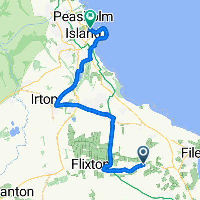
Landslide?
A cycling route starting in Hunmanby, England, United Kingdom.
Overview
About this route
is there a 100m gap in the road, Flomanby Lane to West Street on the A1039 South SE of Scarborough nr. Muston.
- -:--
- Duration
- 10.5 km
- Distance
- 125 m
- Ascent
- 125 m
- Descent
- ---
- Avg. speed
- ---
- Max. altitude

Route quality
Waytypes & surfaces along the route
Waytypes
Road
6.4 km
(61 %)
Quiet road
0.2 km
(2 %)
Undefined
3.9 km
(37 %)
Surfaces
Paved
1.9 km
(18 %)
Asphalt
1.9 km
(18 %)
Undefined
8.6 km
(82 %)
Continue with Bikemap
Use, edit, or download this cycling route
You would like to ride Landslide? or customize it for your own trip? Here is what you can do with this Bikemap route:
Free features
- Save this route as favorite or in collections
- Copy & plan your own version of this route
- Sync your route with Garmin or Wahoo
Premium features
Free trial for 3 days, or one-time payment. More about Bikemap Premium.
- Navigate this route on iOS & Android
- Export a GPX / KML file of this route
- Create your custom printout (try it for free)
- Download this route for offline navigation
Discover more Premium features.
Get Bikemap PremiumFrom our community
Other popular routes starting in Hunmanby
 long one
- Distance
- 20.4 km
- Ascent
- 168 m
- Descent
- 170 m
- Location
- Hunmanby, England, United Kingdom
 1 Bridlington Road, Filey to Reighton, Filey
- Distance
- 5.2 km
- Ascent
- 48 m
- Descent
- 81 m
- Location
- Hunmanby, England, United Kingdom
 2 Main St, Scarborough to 102 Filey Road, Scarborough
- Distance
- 7.6 km
- Ascent
- 126 m
- Descent
- 78 m
- Location
- Hunmanby, England, United Kingdom
 Great Wold Valley from Hunmanby
- Distance
- 33.7 km
- Ascent
- 321 m
- Descent
- 321 m
- Location
- Hunmanby, England, United Kingdom
 Hunmanby to York
- Distance
- 75.5 km
- Ascent
- 312 m
- Descent
- 317 m
- Location
- Hunmanby, England, United Kingdom
 26 Gap Road, Filey to Filey Brigg Country Park, Church Cliff Dr, Filey
- Distance
- 7.5 km
- Ascent
- 46 m
- Descent
- 43 m
- Location
- Hunmanby, England, United Kingdom
 National Yorkshire Wolds Cycle Route 166
- Distance
- 60.4 km
- Ascent
- 432 m
- Descent
- 458 m
- Location
- Hunmanby, England, United Kingdom
 Tour de Yorkshire 2018 Stage 3 last 20km
- Distance
- 20 km
- Ascent
- 209 m
- Descent
- 235 m
- Location
- Hunmanby, England, United Kingdom
Open it in the app