
Seg. 28_alt
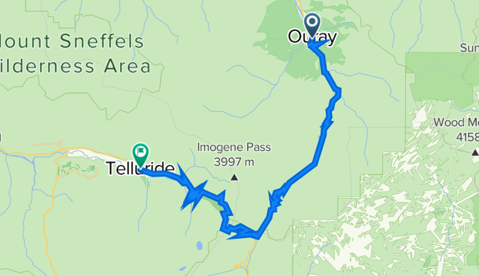
A cycling route starting in Ouray, Colorado, United States.
Overview
About this route
Ophir-Telluride / Imogene Pass
- -:--
- Duration
- 40.5 km
- Distance
- 1,678 m
- Ascent
- 1,389 m
- Descent
- ---
- Avg. speed
- 3,909 m
- Max. altitude

Route quality
Waytypes & surfaces along the route
Waytypes
Cycleway
19.9 km
(49 %)
Track
12.2 km
(30 %)
Surfaces
Paved
23.1 km
(57 %)
Unpaved
17.4 km
(43 %)
Asphalt
22.3 km
(55 %)
Unpaved (undefined)
16.2 km
(40 %)
Continue with Bikemap
Use, edit, or download this cycling route
You would like to ride Seg. 28_alt or customize it for your own trip? Here is what you can do with this Bikemap route:
Free features
- Save this route as favorite or in collections
- Copy & plan your own version of this route
- Sync your route with Garmin or Wahoo
Premium features
Free trial for 3 days, or one-time payment. More about Bikemap Premium.
- Navigate this route on iOS & Android
- Export a GPX / KML file of this route
- Create your custom printout (try it for free)
- Download this route for offline navigation
Discover more Premium features.
Get Bikemap PremiumFrom our community
Other popular routes starting in Ouray
 Slumgullion 2013 Ouray - Silverton out/back
- Distance
- 75.1 km
- Ascent
- 1,553 m
- Descent
- 1,534 m
- Location
- Ouray, Colorado, United States
 2016 Bike Tour: Entire Route
- Distance
- 439.8 km
- Ascent
- 4,132 m
- Descent
- 4,074 m
- Location
- Ouray, Colorado, United States
 Recovered Route
- Distance
- 52.9 km
- Ascent
- 809 m
- Descent
- 632 m
- Location
- Ouray, Colorado, United States
 County Road 10 177, Ridgway to County Road 10 177, Ridgway
- Distance
- 19.6 km
- Ascent
- 471 m
- Descent
- 481 m
- Location
- Ouray, Colorado, United States
 Ouray-Silverton 0608
- Distance
- 34.5 km
- Ascent
- 1,411 m
- Descent
- 946 m
- Location
- Ouray, Colorado, United States
 2016 Bike Tour Day 1: Ouray to Telluride
- Distance
- 81.1 km
- Ascent
- 1,094 m
- Descent
- 791 m
- Location
- Ouray, Colorado, United States
 Stage 8: Ridgeway to Grand Junction (145-141)
- Distance
- 265.9 km
- Ascent
- 1,899 m
- Descent
- 2,619 m
- Location
- Ouray, Colorado, United States
 CR-23, Ridgway to 257 S Cora St, Ridgway
- Distance
- 21 km
- Ascent
- 151 m
- Descent
- 136 m
- Location
- Ouray, Colorado, United States
Open it in the app