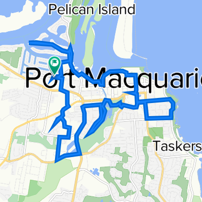
Googik track to lake Innes
- 27 km
- 306 m
- 307 m
- Port Macquarie, New South Wales, Australia
Aim is to stay off road as much as possible.
Head to Bangalay Drive and turn right into Ashdown Drive, irst left into Penshurst Place to ride on the path behind Tacking Point school, which brings you back out onto Bangalay (with a bit of a dog leg).
Turn right and cross at the crossing before Rushcutter Drive where there is a path cutting through to the left. Follow this onto Rushcutter, turn left and then left down a path about 50m further on. This takes you through Rushcutter Reserve (I think) and under Ocean Drive.
Path has you crossing over Emerald Drive. Continue following the path, cross the small bridge and then veer right. Head up the hill (steep climb and not sure of name of street). Turn left at the top and then down the hill, right at bottom and then first left from where you should be able to see the path (might need to ground truth this and get street and reserve names - can do this on 23/24th Feb but happy for you to before then if you can!)
Turn righ onto path and then left onto the boardwalk that takes you through to Crestwood Drive.
Turn left and follow along, up and then down the hill veering left then along a flat section with new houses. About 100m past the kids playground (which is still being built) is the entrance to the Googik Track on your left.
Turn onto this and follow the track through to St Columba school. There is one right hand turn and then the turn up to SCAS is a left hander and well signed.
Ride up to Major Innes drive behind the back of the school and up to Coles. From here stay on the RHS of the road as there is a track that connects parallel to the main road between the houses and the road - right through to the racecourse (crossing Wright's and Lake Roads).
Will have to cross Oxley H'way to get to the Racecourse.
Free trial for 3 days, or one-time payment. More about Bikemap Premium.
Discover more Premium features.
Get Bikemap PremiumOpen it in the app