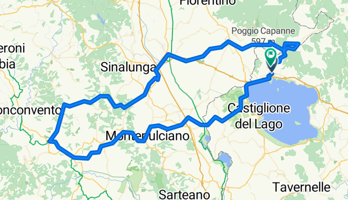
sabato 16/02
A cycling route starting in Tuoro sul Trasimeno, Umbria, Italy.
Overview
About this route
- -:--
- Duration
- 149.8 km
- Distance
- 1,482 m
- Ascent
- 1,401 m
- Descent
- ---
- Avg. speed
- ---
- Avg. speed
Route quality
Waytypes & surfaces along the route
Waytypes
Busy road
80.4 km
(54 %)
Road
21.3 km
(14 %)
Surfaces
Paved
90.3 km
(60 %)
Unpaved
31.3 km
(21 %)
Asphalt
85.2 km
(57 %)
Gravel
12.3 km
(8 %)
Continue with Bikemap
Use, edit, or download this cycling route
You would like to ride sabato 16/02 or customize it for your own trip? Here is what you can do with this Bikemap route:
Free features
- Save this route as favorite or in collections
- Copy & plan your own version of this route
- Sync your route with Garmin or Wahoo
Premium features
Free trial for 3 days, or one-time payment. More about Bikemap Premium.
- Navigate this route on iOS & Android
- Export a GPX / KML file of this route
- Create your custom printout (try it for free)
- Download this route for offline navigation
Discover more Premium features.
Get Bikemap PremiumFrom our community
Other popular routes starting in Tuoro sul Trasimeno
- Tuoro - Montegualandro - Trecine - Passignano
- Distance
- 42.1 km
- Ascent
- 786 m
- Descent
- 784 m
- Location
- Tuoro sul Trasimeno, Umbria, Italy
- Tuoro - Borgo
- Distance
- 11.9 km
- Ascent
- 614 m
- Descent
- 380 m
- Location
- Tuoro sul Trasimeno, Umbria, Italy
- tour del Trasimeno
- Distance
- 58.3 km
- Ascent
- 186 m
- Descent
- 183 m
- Location
- Tuoro sul Trasimeno, Umbria, Italy
- 06 HSL (Tuoro - Città di Castello)
- Distance
- 47.6 km
- Ascent
- 434 m
- Descent
- 412 m
- Location
- Tuoro sul Trasimeno, Umbria, Italy
- sabato 16/02
- Distance
- 149.8 km
- Ascent
- 1,482 m
- Descent
- 1,401 m
- Location
- Tuoro sul Trasimeno, Umbria, Italy
- Giro Trasimeno 2003
- Distance
- 64.5 km
- Ascent
- 118 m
- Descent
- 118 m
- Location
- Tuoro sul Trasimeno, Umbria, Italy
- La Cima KOM
- Distance
- 5.5 km
- Ascent
- 351 m
- Descent
- 201 m
- Location
- Tuoro sul Trasimeno, Umbria, Italy
- 1_tuoro__monte amiata
- Distance
- 80.5 km
- Ascent
- 2,041 m
- Descent
- 655 m
- Location
- Tuoro sul Trasimeno, Umbria, Italy