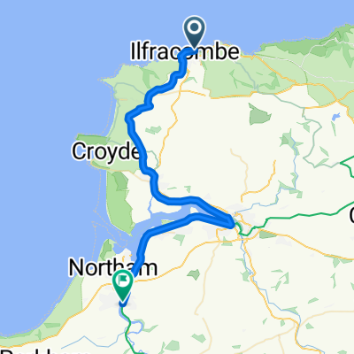
DC2C - Day 1
A cycling route starting in Ilfracombe, England, United Kingdom.
Overview
About this route
Start point in Ilfracombe to Yarde. 36.5 miles
- -:--
- Duration
- 58.7 km
- Distance
- 390 m
- Ascent
- 269 m
- Descent
- ---
- Avg. speed
- ---
- Avg. speed
Route quality
Waytypes & surfaces along the route
Waytypes
Cycleway
27 km
(46 %)
Path
20 km
(34 %)
Surfaces
Paved
34 km
(58 %)
Unpaved
1.8 km
(3 %)
Asphalt
33.5 km
(57 %)
Gravel
1.8 km
(3 %)
Continue with Bikemap
Use, edit, or download this cycling route
You would like to ride DC2C - Day 1 or customize it for your own trip? Here is what you can do with this Bikemap route:
Free features
- Save this route as favorite or in collections
- Copy & plan your own version of this route
- Sync your route with Garmin or Wahoo
Premium features
Free trial for 3 days, or one-time payment. More about Bikemap Premium.
- Navigate this route on iOS & Android
- Export a GPX / KML file of this route
- Create your custom printout (try it for free)
- Download this route for offline navigation
Discover more Premium features.
Get Bikemap PremiumFrom our community
Other popular routes starting in Ilfracombe
- Exmoor Hills
- Distance
- 143 km
- Ascent
- 2,048 m
- Descent
- 2,087 m
- Location
- Ilfracombe, England, United Kingdom
- Day 3
- Distance
- 40.9 km
- Ascent
- 257 m
- Descent
- 266 m
- Location
- Ilfracombe, England, United Kingdom
- Devon C2C
- Distance
- 161.8 km
- Ascent
- 990 m
- Descent
- 965 m
- Location
- Ilfracombe, England, United Kingdom
- Nice ride to work
- Distance
- 10.4 km
- Ascent
- 204 m
- Descent
- 132 m
- Location
- Ilfracombe, England, United Kingdom
- Devon C2C 1 - Short
- Distance
- 21.3 km
- Ascent
- 391 m
- Descent
- 370 m
- Location
- Ilfracombe, England, United Kingdom
- ????
- Distance
- 6.7 km
- Ascent
- 147 m
- Descent
- 150 m
- Location
- Ilfracombe, England, United Kingdom
- Ilfracombe 50km
- Distance
- 50.1 km
- Ascent
- 691 m
- Descent
- 701 m
- Location
- Ilfracombe, England, United Kingdom
- 10.etapa Water Mouth - Ilfracombe a zpět
- Distance
- 9.7 km
- Ascent
- 235 m
- Descent
- 235 m
- Location
- Ilfracombe, England, United Kingdom
Open it in the app