

Wörth-Otterbachtal-Wörth 2016
Teil_1_Wörth-Otterbachtal
A cycling route starting in Wörth an der Isar, Bavaria, Germany.
Overview
About this route
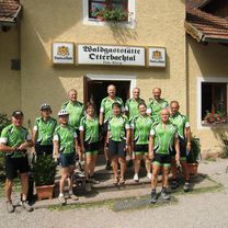
<p>Refreshment stop at Koreawirt on August 20, 2016</p>
Translated, show original (German)- -:--
- Duration
- 71.7 km
- Distance
- 312 m
- Ascent
- 255 m
- Descent
- ---
- Avg. speed
- ---
- Max. altitude

Part of
Wörth-Otterbachtal-Wörth 2016
2 stages
Route photos


Route quality
Waytypes & surfaces along the route
Waytypes
Quiet road
26.5 km
(37 %)
Road
22.9 km
(32 %)
Surfaces
Paved
31.5 km
(44 %)
Unpaved
11.5 km
(16 %)
Asphalt
31.5 km
(44 %)
Gravel
8.6 km
(12 %)
Continue with Bikemap
Use, edit, or download this cycling route
You would like to ride Teil_1_Wörth-Otterbachtal or customize it for your own trip? Here is what you can do with this Bikemap route:
Free features
- Save this route as favorite or in collections
- Copy & plan your own version of this route
- Sync your route with Garmin or Wahoo
Premium features
Free trial for 3 days, or one-time payment. More about Bikemap Premium.
- Navigate this route on iOS & Android
- Export a GPX / KML file of this route
- Create your custom printout (try it for free)
- Download this route for offline navigation
Discover more Premium features.
Get Bikemap PremiumFrom our community
Other popular routes starting in Wörth an der Isar
 Wörth-Mettenbach-Unterröhrenbach-Oberwattenbach-Unterunsbach-Artlkofen-Mirskofen-Altheim-Gretlmühle-Sterneck-Frauenberg-Wölflkofen-Adlkofen-Oberaichbach-Wörth
- Distance
- 49.7 km
- Ascent
- 792 m
- Descent
- 796 m
- Location
- Wörth an der Isar, Bavaria, Germany
 Wörth-Niederaichbach-Thalham-Triendorf-Onersdorf-Hub-Unterschnittenkofen-Oberwolkersdorf-Oberspechtrain-Oberteisbach-Piegendorf-Loiching-Gummering-Wörth
- Distance
- 41.7 km
- Ascent
- 408 m
- Descent
- 409 m
- Location
- Wörth an der Isar, Bavaria, Germany
 Wörth-Landau-Mariakirchen
- Distance
- 60.2 km
- Ascent
- 244 m
- Descent
- 248 m
- Location
- Wörth an der Isar, Bavaria, Germany
 Wörth-Martinshaun-Ergoldsbach-Langenhettenbach-Frauenwies-Ergoldsbach-Stetten-Paindlkofen-Moosthann-Wörth
- Distance
- 38.3 km
- Ascent
- 404 m
- Descent
- 405 m
- Location
- Wörth an der Isar, Bavaria, Germany
 Wörth-Niederaichbach-Wattenbacher_Moos-Unter.-Oberwattenbach-Ergoldsbach-Bayerbach-Mengkofen-Ottering-Thürnthenning-Rimbach-Weng-Wörth
- Distance
- 73.7 km
- Ascent
- 421 m
- Descent
- 423 m
- Location
- Wörth an der Isar, Bavaria, Germany
 Wörth-Kronwieden-Dornwang-Buchreith-Lengthal-Unterhollerau-Moosthenning-DGF-Wörth
- Distance
- 40.8 km
- Ascent
- 172 m
- Descent
- 171 m
- Location
- Wörth an der Isar, Bavaria, Germany
 Hinf_Ergoldsbach-Andermannsdf.-Türkenfeld-Rottenburg-Niedereulenbach-Alzhausen-Rohr-Sallingsberg-Offenstetten-Abensberg
- Distance
- 56.8 km
- Ascent
- 420 m
- Descent
- 422 m
- Location
- Wörth an der Isar, Bavaria, Germany
 Teil_1_Wörth-Otterbachtal
- Distance
- 71.7 km
- Ascent
- 312 m
- Descent
- 255 m
- Location
- Wörth an der Isar, Bavaria, Germany
Open it in the app