
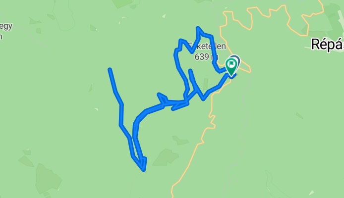
Tamás kút-Imókő forrás-Vöröskő forrás-Tamás kút
A cycling route starting in Bélapátfalva, Heves County, Hungary.
Overview
About this route
There are steep sections. It is slippery when it rains.
- -:--
- Duration
- 21.2 km
- Distance
- 553 m
- Ascent
- 558 m
- Descent
- ---
- Avg. speed
- ---
- Max. altitude

Route quality
Waytypes & surfaces along the route
Waytypes
Track
17.2 km
(81 %)
Path
1.5 km
(7 %)
Undefined
2.5 km
(12 %)
Surfaces
Unpaved
16.1 km
(76 %)
Ground
5.1 km
(24 %)
Loose gravel
4.5 km
(21 %)
Continue with Bikemap
Use, edit, or download this cycling route
You would like to ride Tamás kút-Imókő forrás-Vöröskő forrás-Tamás kút or customize it for your own trip? Here is what you can do with this Bikemap route:
Free features
- Save this route as favorite or in collections
- Copy & plan your own version of this route
- Sync your route with Garmin or Wahoo
Premium features
Free trial for 3 days, or one-time payment. More about Bikemap Premium.
- Navigate this route on iOS & Android
- Export a GPX / KML file of this route
- Create your custom printout (try it for free)
- Download this route for offline navigation
Discover more Premium features.
Get Bikemap PremiumFrom our community
Other popular routes starting in Bélapátfalva
 Bükki Kék 2
- Distance
- 28.2 km
- Ascent
- 776 m
- Descent
- 624 m
- Location
- Bélapátfalva, Heves County, Hungary
 Bél-kör
- Distance
- 17.8 km
- Ascent
- 703 m
- Descent
- 703 m
- Location
- Bélapátfalva, Heves County, Hungary
 2015. júl. 2. 19:13
- Distance
- 11.6 km
- Ascent
- 189 m
- Descent
- 189 m
- Location
- Bélapátfalva, Heves County, Hungary
 Tamás kút-Imókő forrás-Vöröskő forrás-Tamás kút
- Distance
- 21.2 km
- Ascent
- 553 m
- Descent
- 558 m
- Location
- Bélapátfalva, Heves County, Hungary
 A Bükk tetején
- Distance
- 27.4 km
- Ascent
- 760 m
- Descent
- 733 m
- Location
- Bélapátfalva, Heves County, Hungary
 OKT Bükk-átszelő Kék 2
- Distance
- 26.1 km
- Ascent
- 927 m
- Descent
- 988 m
- Location
- Bélapátfalva, Heves County, Hungary
 Bélapátfalva - Szilvásvárad
- Distance
- 11.3 km
- Ascent
- 300 m
- Descent
- 265 m
- Location
- Bélapátfalva, Heves County, Hungary
 Bél-kő
- Distance
- 7.1 km
- Ascent
- 490 m
- Descent
- 8 m
- Location
- Bélapátfalva, Heves County, Hungary
Open it in the app