


Veľký bušinský okruh
A cycling route starting in Veľký Krtíš, Banská Bystrica Region, Slovakia.
Overview
About this route
0
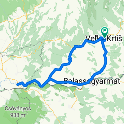
Veľký Krtíš - Bušince and through Kirť and Kiarov to Želoviec and back to Veľký Krtíš. An easy route for recreational cyclists along the border with Hungary near the Ipeľ.
- -:--
- Duration
- 47.9 km
- Distance
- 398 m
- Ascent
- 409 m
- Descent
- ---
- Avg. speed
- 253 m
- Max. altitude
Ďusi
created this 18 years ago
Route quality
Waytypes & surfaces along the route
Waytypes
Road
34 km
71 %
Quiet road
4.8 km
10 %
Undefined
9.1 km
19 %
Surfaces
Paved
31.2 km
(65 %)
Asphalt
31.2 km
65 %
Undefined
16.8 km
35 %
Continue with Bikemap
Use, edit, or download this cycling route
You would like to ride Veľký bušinský okruh or customize it for your own trip? Here is what you can do with this Bikemap route:
Free features
- Save this route as favorite or in collections
- Copy & plan your own version of this route
- Sync your route with Garmin or Wahoo
Premium features
Free trial for 3 days, or one-time payment. More about Bikemap Premium.
- Navigate this route on iOS & Android
- Export a GPX / KML file of this route
- Create your custom printout (try it for free)
- Download this route for offline navigation
Discover more Premium features.
Get Bikemap PremiumFrom our community
Other popular routes starting in Veľký Krtíš

 Červenej armády 54 do Červenej armády 311
- 26.6 km
- 298 m
- 275 m
- Veľký Krtíš, Banská Bystrica Region, Slovakia
 Veľký Krtíš - Čelovce - Sl. Ďarmoty - Veľký Krtíš0
- 68.6 km
- 488 m
- 489 m
- Veľký Krtíš, Banská Bystrica Region, Slovakia
 Stredné Plachtince - Čebovská Bukovina - Sucháň - Stredné Plachtince0
- 53.8 km
- 870 m
- 872 m
- Veľký Krtíš, Banská Bystrica Region, Slovakia

 Varbó-Kér-Zsély-Zahora-Gyarmat-Őrhalom-Varbó2
- 27.5 km
- 170 m
- 170 m
- Veľký Krtíš, Banská Bystrica Region, Slovakia
 Veľký Krtíš - Vinica - Šahy - Sl. Ďarmoty - Veľký Krtíš0
- 105.1 km
- 556 m
- 588 m
- Veľký Krtíš, Banská Bystrica Region, Slovakia
 Červenej armády 54 do Červenej armády 561
- 32.2 km
- 94 m
- 207 m
- Veľký Krtíš, Banská Bystrica Region, Slovakia


Open it in the app