

Mansuè Sacile sugli argini
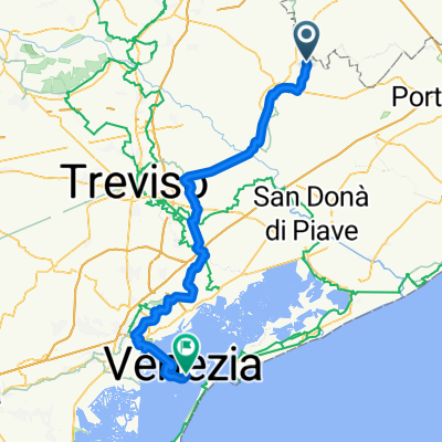
A cycling route starting in Mansuè, Veneto, Italy.
Overview
About this route
The mapped road is not the one that was followed!
- -:--
- Duration
- 31 km
- Distance
- 18 m
- Ascent
- 19 m
- Descent
- ---
- Avg. speed
- ---
- Max. altitude

Continue with Bikemap
Use, edit, or download this cycling route
You would like to ride Mansuè Sacile sugli argini or customize it for your own trip? Here is what you can do with this Bikemap route:
Free features
- Save this route as favorite or in collections
- Copy & plan your own version of this route
- Sync your route with Garmin or Wahoo
Premium features
Free trial for 3 days, or one-time payment. More about Bikemap Premium.
- Navigate this route on iOS & Android
- Export a GPX / KML file of this route
- Create your custom printout (try it for free)
- Download this route for offline navigation
Discover more Premium features.
Get Bikemap PremiumFrom our community
Other popular routes starting in Mansuè
 5. Etappe
- Distance
- 58.2 km
- Ascent
- 76 m
- Descent
- 58 m
- Location
- Mansuè, Veneto, Italy
 Mansuè-Susegana
- Distance
- 72.5 km
- Ascent
- 259 m
- Descent
- 259 m
- Location
- Mansuè, Veneto, Italy
 Via Meduna, Mansuè a Via Meduna, Mansuè
- Distance
- 2.6 km
- Ascent
- 6 m
- Descent
- 9 m
- Location
- Mansuè, Veneto, Italy
 Da Via Cimitero di Baselghelle 5, Mansuè a Via Rigole 9, Mansuè
- Distance
- 78 km
- Ascent
- 443 m
- Descent
- 438 m
- Location
- Mansuè, Veneto, Italy
 Mansuè Cycling
- Distance
- 68 km
- Ascent
- 37 m
- Descent
- 44 m
- Location
- Mansuè, Veneto, Italy
 Mansuè-Motta di Livenza-Oderzo-Lutrano
- Distance
- 34.8 km
- Ascent
- 15 m
- Descent
- 16 m
- Location
- Mansuè, Veneto, Italy
 Mansuè Sacile sugli argini
- Distance
- 31 km
- Ascent
- 18 m
- Descent
- 19 m
- Location
- Mansuè, Veneto, Italy
 Mansuè - Venice
- Distance
- 78.1 km
- Ascent
- 69 m
- Descent
- 82 m
- Location
- Mansuè, Veneto, Italy
Open it in the app