
2019 Eifel Bitburg
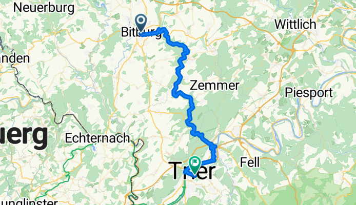
Sa. Bitburg - Trier Hbf
A cycling route starting in Bitburg, Rhineland-Palatinate, Germany.
Overview
About this route
- -:--
- Duration
- 51.9 km
- Distance
- 162 m
- Ascent
- 375 m
- Descent
- ---
- Avg. speed
- ---
- Max. altitude

Part of
2019 Eifel Bitburg
10 stages
Route quality
Waytypes & surfaces along the route
Waytypes
Path
24.9 km
(48 %)
Track
10.9 km
(21 %)
Surfaces
Paved
46.2 km
(89 %)
Unpaved
3.1 km
(6 %)
Asphalt
44.1 km
(85 %)
Gravel
2.6 km
(5 %)
Continue with Bikemap
Use, edit, or download this cycling route
You would like to ride Sa. Bitburg - Trier Hbf or customize it for your own trip? Here is what you can do with this Bikemap route:
Free features
- Save this route as favorite or in collections
- Copy & plan your own version of this route
- Sync your route with Garmin or Wahoo
Premium features
Free trial for 3 days, or one-time payment. More about Bikemap Premium.
- Navigate this route on iOS & Android
- Export a GPX / KML file of this route
- Create your custom printout (try it for free)
- Download this route for offline navigation
Discover more Premium features.
Get Bikemap PremiumFrom our community
Other popular routes starting in Bitburg
 KurzeEifel E2 Bitburg-Gerolstein
- Distance
- 38.7 km
- Ascent
- 389 m
- Descent
- 366 m
- Location
- Bitburg, Rhineland-Palatinate, Germany
 2025 Tag 7 Bitburg-Hellenthal
- Distance
- 93.6 km
- Ascent
- 1,355 m
- Descent
- 1,284 m
- Location
- Bitburg, Rhineland-Palatinate, Germany
 Mötscher Straße 42, Bitburg to Spangdahlemer Straße, Bitburg
- Distance
- 3.8 km
- Ascent
- 25 m
- Descent
- 22 m
- Location
- Bitburg, Rhineland-Palatinate, Germany
 Neuerburg - Stausee Bitburg
- Distance
- 83.7 km
- Ascent
- 951 m
- Descent
- 951 m
- Location
- Bitburg, Rhineland-Palatinate, Germany
 Bitburg - Minden/Sauer CLONED FROM ROUTE 1799
- Distance
- 22.6 km
- Ascent
- 98 m
- Descent
- 285 m
- Location
- Bitburg, Rhineland-Palatinate, Germany
 Do. kurze Nordschleife
- Distance
- 57.3 km
- Ascent
- 675 m
- Descent
- 675 m
- Location
- Bitburg, Rhineland-Palatinate, Germany
 SoTo 2018/18: Bitburg - Kronenburg
- Distance
- 68.5 km
- Ascent
- 483 m
- Descent
- 333 m
- Location
- Bitburg, Rhineland-Palatinate, Germany
 Bitburg - Thionville
- Distance
- 196.4 km
- Ascent
- 647 m
- Descent
- 647 m
- Location
- Bitburg, Rhineland-Palatinate, Germany
Open it in the app