

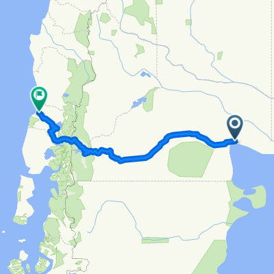
SAN ANTONIO ESTE a PUNTA PERDICES
A cycling route starting in San Antonio Oeste, Río Negro Province, Argentina.
Overview
About this route
Recorrido Mountain desde el puerto de San antonio Este a el balneario de Punta perdices, un verdadero paraiso en la costa Argentina
- -:--
- Duration
- 4.6 km
- Distance
- 4 m
- Ascent
- 15 m
- Descent
- ---
- Avg. speed
- ---
- Max. altitude

Route quality
Waytypes & surfaces along the route
Waytypes
Quiet road
4.3 km
(94 %)
Undefined
0.3 km
(6 %)
Surfaces
Paved
0.3 km
(6 %)
Unpaved
4.3 km
(94 %)
Unpaved (undefined)
3.4 km
(73 %)
Pebblestone
1 km
(21 %)
Asphalt
0.3 km
(6 %)
Route highlights
Points of interest along the route

Point of interest after 1.3 km
Mirador Norte, frente al puerto.

Point of interest after 4.5 km
Punta perdices,, relax y bici
Continue with Bikemap
Use, edit, or download this cycling route
You would like to ride SAN ANTONIO ESTE a PUNTA PERDICES or customize it for your own trip? Here is what you can do with this Bikemap route:
Free features
- Save this route as favorite or in collections
- Copy & plan your own version of this route
- Sync your route with Garmin or Wahoo
Premium features
Free trial for 3 days, or one-time payment. More about Bikemap Premium.
- Navigate this route on iOS & Android
- Export a GPX / KML file of this route
- Create your custom printout (try it for free)
- Download this route for offline navigation
Discover more Premium features.
Get Bikemap PremiumFrom our community
Other popular routes starting in San Antonio Oeste
 San Antonio del Oeste - Valdés
- Distance
- 465.7 km
- Ascent
- 544 m
- Descent
- 538 m
- Location
- San Antonio Oeste, Río Negro Province, Argentina
 Vuelta a la Argentina. Parte 10
- Distance
- 189.9 km
- Ascent
- 196 m
- Descent
- 218 m
- Location
- San Antonio Oeste, Río Negro Province, Argentina
 FUERTE ARGENTINO--LAS GRUTAS,,
- Distance
- 35.8 km
- Ascent
- 36 m
- Descent
- 39 m
- Location
- San Antonio Oeste, Río Negro Province, Argentina
 Etap XVIII Las Grutas i na północ
- Distance
- 4,025.7 km
- Ascent
- 17,295 m
- Descent
- 17,218 m
- Location
- San Antonio Oeste, Río Negro Province, Argentina
 Las grutas
- Distance
- 37.4 km
- Ascent
- 233 m
- Descent
- 233 m
- Location
- San Antonio Oeste, Río Negro Province, Argentina
 Etap XVII RN23 i na południe
- Distance
- 2,268.6 km
- Ascent
- 14,576 m
- Descent
- 14,207 m
- Location
- San Antonio Oeste, Río Negro Province, Argentina
 De Antartida Argentina 1858, San Antonio Oeste a Martin Fierro 241, San Antonio Oeste
- Distance
- 35 km
- Ascent
- 129 m
- Descent
- 140 m
- Location
- San Antonio Oeste, Río Negro Province, Argentina
 San Antonio Oeste to Valdivia with stops
- Distance
- 1,031.4 km
- Ascent
- 2,115 m
- Descent
- 2,114 m
- Location
- San Antonio Oeste, Río Negro Province, Argentina
Open it in the app