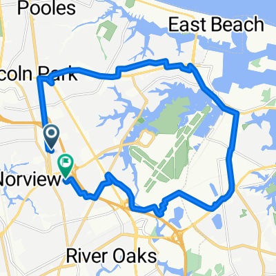
urban trail century
A cycling route starting in Norfolk, Virginia, United States.
Overview
About this route
- -:--
- Duration
- 166.3 km
- Distance
- 68 m
- Ascent
- 67 m
- Descent
- ---
- Avg. speed
- ---
- Max. altitude
Continue with Bikemap
Use, edit, or download this cycling route
You would like to ride urban trail century or customize it for your own trip? Here is what you can do with this Bikemap route:
Free features
- Save this route as favorite or in collections
- Copy & plan your own version of this route
- Split it into stages to create a multi-day tour
- Sync your route with Garmin or Wahoo
Premium features
Free trial for 3 days, or one-time payment. More about Bikemap Premium.
- Navigate this route on iOS & Android
- Export a GPX / KML file of this route
- Create your custom printout (try it for free)
- Download this route for offline navigation
Discover more Premium features.
Get Bikemap PremiumFrom our community
Other popular routes starting in Norfolk
- NORFOLK BASE/Sewels Point Road
- Distance
- 34.7 km
- Ascent
- 27 m
- Descent
- 30 m
- Location
- Norfolk, Virginia, United States
- urban trail century
- Distance
- 166.3 km
- Ascent
- 68 m
- Descent
- 67 m
- Location
- Norfolk, Virginia, United States
- Airport ride
- Distance
- 44.3 km
- Ascent
- 59 m
- Descent
- 59 m
- Location
- Norfolk, Virginia, United States
- Dismal Swamp
- Distance
- 85.1 km
- Ascent
- 66 m
- Descent
- 66 m
- Location
- Norfolk, Virginia, United States
- Long ride through Norfolk
- Distance
- 43.3 km
- Ascent
- 20 m
- Descent
- 19 m
- Location
- Norfolk, Virginia, United States
- Little Creek/NOB loop
- Distance
- 50.5 km
- Ascent
- 45 m
- Descent
- 48 m
- Location
- Norfolk, Virginia, United States
- Xmas and garages
- Distance
- 25.8 km
- Ascent
- 50 m
- Descent
- 49 m
- Location
- Norfolk, Virginia, United States
- 415 St Paul's Blvd, Norfolk to 3814 Cove Rd, Virginia Beach
- Distance
- 17.7 km
- Ascent
- 55 m
- Descent
- 55 m
- Location
- Norfolk, Virginia, United States
Open it in the app