

Tierra Muerta, Palancares
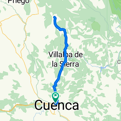
A cycling route starting in Cuenca, Castille-La Mancha, Spain.
Overview
About this route
Ruta circular desde Cuenca por el paraje de Tierra Muerta y los Palancares.
- -:--
- Duration
- 57.1 km
- Distance
- 649 m
- Ascent
- 645 m
- Descent
- ---
- Avg. speed
- ---
- Max. altitude
Route highlights
Points of interest along the route
Point of interest after 21.2 km
Cotillas, sitio idóneo para oír la berrea de los ciervos.
Point of interest after 21.7 km
Yacimiento de las hoyas. No visitable.
Point of interest after 23.3 km
Las torcas
Point of interest after 30.5 km
Pino Abuelo
Point of interest after 33.4 km
Pino Candelabro
Point of interest after 34 km
Estación del tren
Point of interest after 34.4 km
Parcela con más pinos negrales de toda europa.
Point of interest after 39.2 km
Campamento de los Palancares
Point of interest after 39.4 km
Fuente del Royo.
Point of interest after 41.5 km
Hoz de San Miguel
Point of interest after 44 km
Hoz del Buey
Continue with Bikemap
Use, edit, or download this cycling route
You would like to ride Tierra Muerta, Palancares or customize it for your own trip? Here is what you can do with this Bikemap route:
Free features
- Save this route as favorite or in collections
- Copy & plan your own version of this route
- Sync your route with Garmin or Wahoo
Premium features
Free trial for 3 days, or one-time payment. More about Bikemap Premium.
- Navigate this route on iOS & Android
- Export a GPX / KML file of this route
- Create your custom printout (try it for free)
- Download this route for offline navigation
Discover more Premium features.
Get Bikemap PremiumFrom our community
Other popular routes starting in Cuenca
 Piedra del Yunque
- Distance
- 57.9 km
- Ascent
- 676 m
- Descent
- 668 m
- Location
- Cuenca, Castille-La Mancha, Spain
 Carrera Montana de Jabaga en Bici
- Distance
- 51.9 km
- Ascent
- 811 m
- Descent
- 811 m
- Location
- Cuenca, Castille-La Mancha, Spain
 Cuenca - Villalba - Fresneda - Villalba - Cuenca
- Distance
- 85.1 km
- Ascent
- 813 m
- Descent
- 790 m
- Location
- Cuenca, Castille-La Mancha, Spain
 Palomera, Buenache de la Sierra, Valdecabras.
- Distance
- 52.8 km
- Ascent
- 612 m
- Descent
- 613 m
- Location
- Cuenca, Castille-La Mancha, Spain
 2007 (Excursión Cuenca)
- Distance
- 105.9 km
- Ascent
- 914 m
- Descent
- 914 m
- Location
- Cuenca, Castille-La Mancha, Spain
 Primer tramo Maraton "Sendas de Cuenca"
- Distance
- 37.7 km
- Ascent
- 668 m
- Descent
- 670 m
- Location
- Cuenca, Castille-La Mancha, Spain
 Ruta de los Belenes de la senda de la Rambla
- Distance
- 49 km
- Ascent
- 754 m
- Descent
- 754 m
- Location
- Cuenca, Castille-La Mancha, Spain
 Vallejo del Pumar
- Distance
- 45.3 km
- Ascent
- 655 m
- Descent
- 654 m
- Location
- Cuenca, Castille-La Mancha, Spain
Open it in the app