

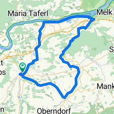
Schöllenbach - Plankenstein - Luft - Pöchlarn - Sarling
A cycling route starting in Petzenkirchen, Lower Austria, Austria.
Overview
About this route
- -:--
- Duration
- 93.7 km
- Distance
- 1,642 m
- Ascent
- 1,657 m
- Descent
- ---
- Avg. speed
- 764 m
- Max. altitude
Route quality
Waytypes & surfaces along the route
Waytypes
Road
46.7 km
(50 %)
Busy road
40.2 km
(43 %)
Surfaces
Paved
74.7 km
(80 %)
Asphalt
74.2 km
(79 %)
Paved (undefined)
0.4 km
(<1 %)
Continue with Bikemap
Use, edit, or download this cycling route
You would like to ride Schöllenbach - Plankenstein - Luft - Pöchlarn - Sarling or customize it for your own trip? Here is what you can do with this Bikemap route:
Free features
- Save this route as favorite or in collections
- Copy & plan your own version of this route
- Split it into stages to create a multi-day tour
- Sync your route with Garmin or Wahoo
Premium features
Free trial for 3 days, or one-time payment. More about Bikemap Premium.
- Navigate this route on iOS & Android
- Export a GPX / KML file of this route
- Create your custom printout (try it for free)
- Download this route for offline navigation
Discover more Premium features.
Get Bikemap PremiumFrom our community
Other popular routes starting in Petzenkirchen
 Wieselburg - Wastl - Erlaufboden - Wieselburg
- Distance
- 104.3 km
- Ascent
- 1,460 m
- Descent
- 1,461 m
- Location
- Petzenkirchen, Lower Austria, Austria
 W-Diesendorf-Melk(Kraftwerk)-pöchlarn-w
- Distance
- 53.2 km
- Ascent
- 213 m
- Descent
- 212 m
- Location
- Petzenkirchen, Lower Austria, Austria
 Texingtal
- Distance
- 65 km
- Ascent
- 513 m
- Descent
- 512 m
- Location
- Petzenkirchen, Lower Austria, Austria
 Schöllenbach - Plankenstein - Luft - Pöchlarn - Sarling
- Distance
- 93.7 km
- Ascent
- 1,642 m
- Descent
- 1,657 m
- Location
- Petzenkirchen, Lower Austria, Austria
 Wildpark Hochrieß
- Distance
- 7.5 km
- Ascent
- 59 m
- Descent
- 20 m
- Location
- Petzenkirchen, Lower Austria, Austria
 Kendl - Rainberg - Brunnwiesen - Petzenkirchen - Kendl
- Distance
- 15.8 km
- Ascent
- 182 m
- Descent
- 187 m
- Location
- Petzenkirchen, Lower Austria, Austria
 Wieselburg Großa Hochriess Purgstall Runde
- Distance
- 20.5 km
- Ascent
- 228 m
- Descent
- 228 m
- Location
- Petzenkirchen, Lower Austria, Austria
 Ybbs-Erlauf- Donau - Melk - Tal Runde Sep, 22
- Distance
- 212.8 km
- Ascent
- 2,581 m
- Descent
- 2,584 m
- Location
- Petzenkirchen, Lower Austria, Austria
Open it in the app