- 47.5 km
- 734 m
- 727 m
- Happurg, Bavaria, Germany
Lichtenegg - Keilberg - Steinere Rinne - Jungfernsprung
A cycling route starting in Happurg, Bavaria, Germany.
Overview
About this route
Start and finish at the parking lot at Happurger Reservoir.
Nice places to stop over in Lichtenegg, Egensbach, Engeltahl
- -:--
- Duration
- 59.5 km
- Distance
- 1,301 m
- Ascent
- 1,298 m
- Descent
- ---
- Avg. speed
- ---
- Max. altitude
created this 6 years ago
Route quality
Waytypes & surfaces along the route
Waytypes
Track
36.3 km
(61 %)
Path
12.5 km
(21 %)
Surfaces
Paved
6.5 km
(11 %)
Unpaved
42.8 km
(72 %)
Ground
18.4 km
(31 %)
Gravel
15.5 km
(26 %)
Route highlights
Points of interest along the route
Point of interest after 3 km
Jungfernsprung
Point of interest after 17.7 km
Steinerne Rinne
Point of interest after 20.6 km
Landgasthaus "Zum Stillen Bächlein"
Point of interest after 22.5 km
Keilberg Kapelle
Point of interest after 47.1 km
Burgruine Lichteneck, Einkehrmöglichkeit im Gasthaus "Altes Schloss"
Point of interest after 59.5 km
Start und Ziel: Parkplatz Happurger Stausee
Continue with Bikemap
Use, edit, or download this cycling route
You would like to ride Lichtenegg - Keilberg - Steinere Rinne - Jungfernsprung or customize it for your own trip? Here is what you can do with this Bikemap route:
Free features
- Save this route as favorite or in collections
- Copy & plan your own version of this route
- Sync your route with Garmin or Wahoo
Premium features
Free trial for 3 days, or one-time payment. More about Bikemap Premium.
- Navigate this route on iOS & Android
- Export a GPX / KML file of this route
- Create your custom printout (try it for free)
- Download this route for offline navigation
Discover more Premium features.
Get Bikemap PremiumFrom our community
Other popular routes starting in Happurg
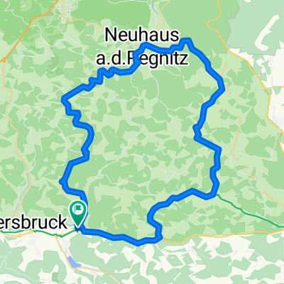
- Vom Am Baggersee in Happurg nach Velden und wieder zurück
- Hirschbach
- 60 km
- 668 m
- 668 m
- Happurg, Bavaria, Germany
- Rundtour "Hohenstadt/Neuhaus/Hohenstadt"
- 60.4 km
- 529 m
- 526 m
- Happurg, Bavaria, Germany
- Happurg-Neukirchen-Sulzbach Rosenberg-Fürnried(56,7 km)
- 58.5 km
- 992 m
- 991 m
- Happurg, Bavaria, Germany
- Hersbruck -Vorra-Hirschbach-Oed
- 46.7 km
- 338 m
- 339 m
- Happurg, Bavaria, Germany
- D_Bayern_Pommelsbrunn-800hmrWeg_RR-17,4km-780hm-200Min
- 17.4 km
- 832 m
- 829 m
- Happurg, Bavaria, Germany
- Lichtenegg - Keilberg - Steinere Rinne - Jungfernsprung
- 59.5 km
- 1,301 m
- 1,298 m
- Happurg, Bavaria, Germany
- D_Bayern_Happurger Stausee-Deckersberg-Mosenhof
- 24 km
- 556 m
- 556 m
- Happurg, Bavaria, Germany
Open it in the app


