

Aarerundfahrt mit Abkürzungsmöglichkeiten
A cycling route starting in Trimbach, Canton of Solothurn, Switzerland.
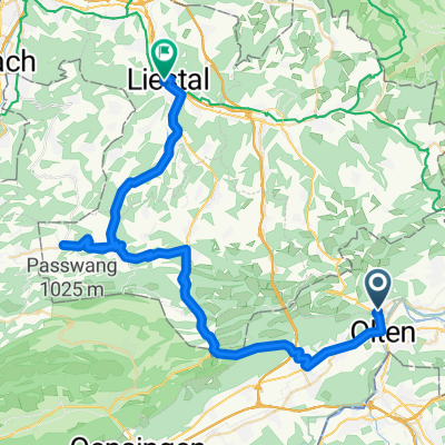
Overview
About this route
The route runs largely along the Aare and can be shortened at various points. The turning point in Aarau is the Aarer restaurant for refreshment.
- -:--
- Duration
- 32.5 km
- Distance
- 240 m
- Ascent
- 240 m
- Descent
- ---
- Avg. speed
- ---
- Max. altitude
Continue with Bikemap
Use, edit, or download this cycling route
You would like to ride Aarerundfahrt mit Abkürzungsmöglichkeiten or customize it for your own trip? Here is what you can do with this Bikemap route:
Free features
- Save this route as favorite or in collections
- Copy & plan your own version of this route
- Sync your route with Garmin or Wahoo
Premium features
Free trial for 3 days, or one-time payment. More about Bikemap Premium.
- Navigate this route on iOS & Android
- Export a GPX / KML file of this route
- Create your custom printout (try it for free)
- Download this route for offline navigation
Discover more Premium features.
Get Bikemap PremiumFrom our community
Other popular routes starting in Trimbach
 Teil der Sonntagsgigathlonstrecke
- Distance
- 58.1 km
- Ascent
- 1,203 m
- Descent
- 1,197 m
- Location
- Trimbach, Canton of Solothurn, Switzerland
 Modif Belchen
- Distance
- 42.3 km
- Ascent
- 1,073 m
- Descent
- 1,093 m
- Location
- Trimbach, Canton of Solothurn, Switzerland
 Nach Bretzwil durchs Baselland bis nach Liestal
- Distance
- 48.4 km
- Ascent
- 780 m
- Descent
- 866 m
- Location
- Trimbach, Canton of Solothurn, Switzerland
 Olten-Entlebuch-Sörenberg-Giswil-Brünig-Brienz
- Distance
- 117.9 km
- Ascent
- 1,722 m
- Descent
- 1,569 m
- Location
- Trimbach, Canton of Solothurn, Switzerland
 Trimbach - Telli mit Velo
- Distance
- 31.7 km
- Ascent
- 173 m
- Descent
- 174 m
- Location
- Trimbach, Canton of Solothurn, Switzerland
 Lostorf,Küttigen, Aarau,Trimbach
- Distance
- 34.1 km
- Ascent
- 533 m
- Descent
- 488 m
- Location
- Trimbach, Canton of Solothurn, Switzerland
 Aarerundfahrt mit Abkürzungsmöglichkeiten
- Distance
- 32.5 km
- Ascent
- 240 m
- Descent
- 240 m
- Location
- Trimbach, Canton of Solothurn, Switzerland
 Wartenfels-Burgweid-Läufelfingen-Schmutzberg-Willihus- Belschenflue-Wuesthöchi-Bärenwil
- Distance
- 41 km
- Ascent
- 1,027 m
- Descent
- 1,028 m
- Location
- Trimbach, Canton of Solothurn, Switzerland
Open it in the app