

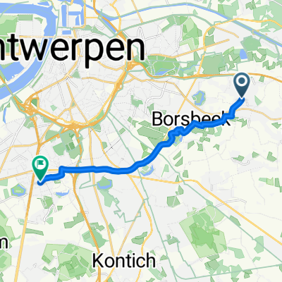
vremde - schorre in boom
A cycling route starting in Wommelgem, Flemish Region, Belgium.
Overview
About this route
Vremde - schorre in tree via nete (Duffel)
- -:--
- Duration
- 48.7 km
- Distance
- 43 m
- Ascent
- 43 m
- Descent
- ---
- Avg. speed
- ---
- Max. altitude

Route quality
Waytypes & surfaces along the route
Waytypes
Cycleway
29.2 km
(60 %)
Road
9.3 km
(19 %)
Surfaces
Paved
25.3 km
(52 %)
Asphalt
23.4 km
(48 %)
Concrete
1.5 km
(3 %)
Continue with Bikemap
Use, edit, or download this cycling route
You would like to ride vremde - schorre in boom or customize it for your own trip? Here is what you can do with this Bikemap route:
Free features
- Save this route as favorite or in collections
- Copy & plan your own version of this route
- Sync your route with Garmin or Wahoo
Premium features
Free trial for 3 days, or one-time payment. More about Bikemap Premium.
- Navigate this route on iOS & Android
- Export a GPX / KML file of this route
- Create your custom printout (try it for free)
- Download this route for offline navigation
Discover more Premium features.
Get Bikemap PremiumFrom our community
Other popular routes starting in Wommelgem
 wommelgem bad
- Distance
- 555.6 km
- Ascent
- 895 m
- Descent
- 767 m
- Location
- Wommelgem, Flemish Region, Belgium
 sint-kateleine waver (mechelen) mtb
- Distance
- 17.2 km
- Ascent
- 17 m
- Descent
- 20 m
- Location
- Wommelgem, Flemish Region, Belgium
 brasschaat
- Distance
- 76.1 km
- Ascent
- 66 m
- Descent
- 67 m
- Location
- Wommelgem, Flemish Region, Belgium
 naar kapellen
- Distance
- 28.4 km
- Ascent
- 20 m
- Descent
- 18 m
- Location
- Wommelgem, Flemish Region, Belgium
 From Wommelgem to Antwerp
- Distance
- 12.2 km
- Ascent
- 14 m
- Descent
- 6 m
- Location
- Wommelgem, Flemish Region, Belgium
 64.5km vanaf vremde
- Distance
- 64.5 km
- Ascent
- 32 m
- Descent
- 31 m
- Location
- Wommelgem, Flemish Region, Belgium
 From Wommelgem to Antwerp
- Distance
- 12.5 km
- Ascent
- 11 m
- Descent
- 3 m
- Location
- Wommelgem, Flemish Region, Belgium
 Ranst
Ranst- Distance
- 22.4 km
- Ascent
- 16 m
- Descent
- 16 m
- Location
- Wommelgem, Flemish Region, Belgium
Open it in the app