

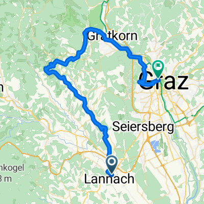
Lannach Radfahren
A cycling route starting in Lannach, Styria, Austria.
Overview
About this route
2713®
- -:--
- Duration
- 55.1 km
- Distance
- 696 m
- Ascent
- 755 m
- Descent
- ---
- Avg. speed
- ---
- Max. altitude
Route quality
Waytypes & surfaces along the route
Waytypes
Quiet road
15.4 km
(28 %)
Cycleway
8.8 km
(16 %)
Surfaces
Paved
26.5 km
(48 %)
Asphalt
26.5 km
(48 %)
Undefined
28.7 km
(52 %)
Continue with Bikemap
Use, edit, or download this cycling route
You would like to ride Lannach Radfahren or customize it for your own trip? Here is what you can do with this Bikemap route:
Free features
- Save this route as favorite or in collections
- Copy & plan your own version of this route
- Sync your route with Garmin or Wahoo
Premium features
Free trial for 3 days, or one-time payment. More about Bikemap Premium.
- Navigate this route on iOS & Android
- Export a GPX / KML file of this route
- Create your custom printout (try it for free)
- Download this route for offline navigation
Discover more Premium features.
Get Bikemap PremiumFrom our community
Other popular routes starting in Lannach
 03 - Lieboch - Graz (über Rein)
- Distance
- 56.3 km
- Ascent
- 864 m
- Descent
- 834 m
- Location
- Lannach, Styria, Austria
 Lannach-Tour - von den Straußeneiern zum Kernöl
- Distance
- 49.5 km
- Ascent
- 660 m
- Descent
- 658 m
- Location
- Lannach, Styria, Austria
 Hauptstraße 68, Heuholz nach Hauptstraße 68, Heuholz
- Distance
- 40.3 km
- Ascent
- 715 m
- Descent
- 714 m
- Location
- Lannach, Styria, Austria
 2. Lannacher Radtag am 17. Juni 2012 - Strecke B
- Distance
- 81.7 km
- Ascent
- 655 m
- Descent
- 652 m
- Location
- Lannach, Styria, Austria
 West-Stmk mit vielen Bergen/überarbeitet
- Distance
- 121 km
- Ascent
- 2,595 m
- Descent
- 2,528 m
- Location
- Lannach, Styria, Austria
 2. Lannacher Radmarathon am 17.6.2012 - Strecke B
- Distance
- 81.7 km
- Ascent
- 647 m
- Descent
- 644 m
- Location
- Lannach, Styria, Austria
 Lannacher E-Bike-Radstrecke
- Distance
- 49.2 km
- Ascent
- 719 m
- Descent
- 719 m
- Location
- Lannach, Styria, Austria

Open it in the app