

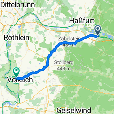
Sand a.Main, Allemagne / Volkach, Allemagne
A cycling route starting in Sand, Bavaria, Germany.
Overview
About this route
Camping Escherndorf am Main
An der Gieß 9a, 97332 Volkach, Germany
campingplatz-mainschleife.de
- -:--
- Duration
- 70 km
- Distance
- 40 m
- Ascent
- 74 m
- Descent
- ---
- Avg. speed
- ---
- Max. altitude

Route quality
Waytypes & surfaces along the route
Waytypes
Path
39.2 km
(56 %)
Track
11.2 km
(16 %)
Surfaces
Paved
53.9 km
(77 %)
Unpaved
9.8 km
(14 %)
Asphalt
51.1 km
(73 %)
Loose gravel
7 km
(10 %)
Continue with Bikemap
Use, edit, or download this cycling route
You would like to ride Sand a.Main, Allemagne / Volkach, Allemagne or customize it for your own trip? Here is what you can do with this Bikemap route:
Free features
- Save this route as favorite or in collections
- Copy & plan your own version of this route
- Sync your route with Garmin or Wahoo
Premium features
Free trial for 3 days, or one-time payment. More about Bikemap Premium.
- Navigate this route on iOS & Android
- Export a GPX / KML file of this route
- Create your custom printout (try it for free)
- Download this route for offline navigation
Discover more Premium features.
Get Bikemap PremiumFrom our community
Other popular routes starting in Sand
 von Sand am Main nach Untereuerheim und Zurück
- Distance
- 45.4 km
- Ascent
- 117 m
- Descent
- 119 m
- Location
- Sand, Bavaria, Germany
 Sau- Renner- und SchlangenwegRunde
- Distance
- 25.2 km
- Ascent
- 379 m
- Descent
- 381 m
- Location
- Sand, Bavaria, Germany
 Ebersberger Antenne
- Distance
- 18 km
- Ascent
- 520 m
- Descent
- 516 m
- Location
- Sand, Bavaria, Germany
 11.07.25 Sand am Main-Sommerach (8.Etappe)
- Distance
- 73 km
- Ascent
- 83 m
- Descent
- 129 m
- Location
- Sand, Bavaria, Germany
 Unterfranken Rundfahrt 3. Etappe
- Distance
- 83.8 km
- Ascent
- 758 m
- Descent
- 756 m
- Location
- Sand, Bavaria, Germany
 sand-volknach
- Distance
- 35.9 km
- Ascent
- 153 m
- Descent
- 181 m
- Location
- Sand, Bavaria, Germany
 Mainradtour 2013 Dritte Etappe
- Distance
- 57.9 km
- Ascent
- 109 m
- Descent
- 129 m
- Location
- Sand, Bavaria, Germany
 sand am main a wurtzburg du 20 au 21
- Distance
- 78.1 km
- Ascent
- 189 m
- Descent
- 237 m
- Location
- Sand, Bavaria, Germany
Open it in the app