Mittelrhein extrem
A cycling route starting in Gau-Algesheim, Rhineland-Palatinate, Germany.
Overview
About this route
Von Gau-Algesheim über die Lauschhütte üdurch alle Rhein-Nebentäler bis Urbar
- -:--
- Duration
- 178.2 km
- Distance
- 2,380 m
- Ascent
- 2,379 m
- Descent
- ---
- Avg. speed
- ---
- Avg. speed
Route quality
Waytypes & surfaces along the route
Waytypes
Road
63.7 km
(36 %)
Busy road
59.9 km
(34 %)
Surfaces
Paved
134 km
(75 %)
Unpaved
6.7 km
(4 %)
Asphalt
110.5 km
(62 %)
Paved (undefined)
19.6 km
(11 %)
Continue with Bikemap
Use, edit, or download this cycling route
You would like to ride Mittelrhein extrem or customize it for your own trip? Here is what you can do with this Bikemap route:
Free features
- Save this route as favorite or in collections
- Copy & plan your own version of this route
- Sync your route with Garmin or Wahoo
Premium features
Free trial for 3 days, or one-time payment. More about Bikemap Premium.
- Navigate this route on iOS & Android
- Export a GPX / KML file of this route
- Create your custom printout (try it for free)
- Download this route for offline navigation
Discover more Premium features.
Get Bikemap PremiumFrom our community
Other popular routes starting in Gau-Algesheim
- 003b Ingelheim - Lauschhütte - Roth - Ingelheim
- Distance
- 60.7 km
- Ascent
- 694 m
- Descent
- 694 m
- Location
- Gau-Algesheim, Rhineland-Palatinate, Germany
- 001a Ingelheim - Rümmelsheim - Daxweiler - Ingelheim
- Distance
- 67.2 km
- Ascent
- 784 m
- Descent
- 778 m
- Location
- Gau-Algesheim, Rhineland-Palatinate, Germany
- 016b Ingelheim - Hergenfeld - Schöneberg - Stromberg - Roth - Ingelheim
- Distance
- 66.4 km
- Ascent
- 795 m
- Descent
- 790 m
- Location
- Gau-Algesheim, Rhineland-Palatinate, Germany
- Tour de Hügel No.1
- Distance
- 80.6 km
- Ascent
- 667 m
- Descent
- 670 m
- Location
- Gau-Algesheim, Rhineland-Palatinate, Germany
- 006e Klassiker plus²
- Distance
- 53.3 km
- Ascent
- 352 m
- Descent
- 350 m
- Location
- Gau-Algesheim, Rhineland-Palatinate, Germany
- 016a Ingelheim - Schöneberg - Seibersbach - Stromberg - Roth - Ingelheim
- Distance
- 70.3 km
- Ascent
- 801 m
- Descent
- 799 m
- Location
- Gau-Algesheim, Rhineland-Palatinate, Germany
- 006b Ingelheim - Sprendlingen - Wolfsheim - Saulheim - Ingelheim
- Distance
- 55.4 km
- Ascent
- 510 m
- Descent
- 489 m
- Location
- Gau-Algesheim, Rhineland-Palatinate, Germany
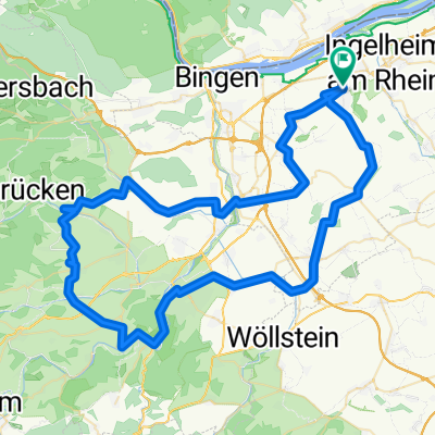
- 003a Ingelheim - Lauschhütte - Dörrebach - Ingelheim
- Distance
- 67.7 km
- Ascent
- 762 m
- Descent
- 763 m
- Location
- Gau-Algesheim, Rhineland-Palatinate, Germany
Open it in the app