

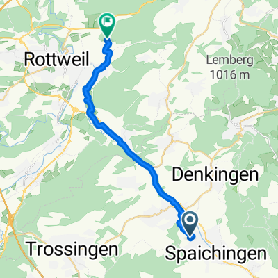
Spaich.-Linsenb.
A cycling route starting in Spaichingen, Baden-Wurttemberg, Germany.
Overview
About this route
- -:--
- Duration
- 15.2 km
- Distance
- 51 m
- Ascent
- 133 m
- Descent
- ---
- Avg. speed
- ---
- Max. altitude

Route quality
Waytypes & surfaces along the route
Waytypes
Track
4.7 km
(31 %)
Path
3.8 km
(25 %)
Surfaces
Paved
13.1 km
(86 %)
Unpaved
0.5 km
(3 %)
Asphalt
11.9 km
(78 %)
Paved (undefined)
1.2 km
(8 %)
Continue with Bikemap
Use, edit, or download this cycling route
You would like to ride Spaich.-Linsenb. or customize it for your own trip? Here is what you can do with this Bikemap route:
Free features
- Save this route as favorite or in collections
- Copy & plan your own version of this route
- Sync your route with Garmin or Wahoo
Premium features
Free trial for 3 days, or one-time payment. More about Bikemap Premium.
- Navigate this route on iOS & Android
- Export a GPX / KML file of this route
- Create your custom printout (try it for free)
- Download this route for offline navigation
Discover more Premium features.
Get Bikemap PremiumFrom our community
Other popular routes starting in Spaichingen
 Spaß mit einem Gang
- Distance
- 53.7 km
- Ascent
- 271 m
- Descent
- 500 m
- Location
- Spaichingen, Baden-Wurttemberg, Germany
 Rund Spaichingen
- Distance
- 24.4 km
- Ascent
- 216 m
- Descent
- 216 m
- Location
- Spaichingen, Baden-Wurttemberg, Germany
 Spaichingen - Horb via FDS
- Distance
- 92.2 km
- Ascent
- 570 m
- Descent
- 750 m
- Location
- Spaichingen, Baden-Wurttemberg, Germany
 Weils Spass macht !
- Distance
- 17.9 km
- Ascent
- 179 m
- Descent
- 204 m
- Location
- Spaichingen, Baden-Wurttemberg, Germany
 Spaichingen -- Klippeneck
- Distance
- 10.4 km
- Ascent
- 426 m
- Descent
- 132 m
- Location
- Spaichingen, Baden-Wurttemberg, Germany
 _Spaichingen bis hinter Oberlehen Stand 02.05.2020
- Distance
- 97.7 km
- Ascent
- 2,940 m
- Descent
- 2,456 m
- Location
- Spaichingen, Baden-Wurttemberg, Germany
 Alter Berg, Glatter Fels, Schrofe
- Distance
- 34.7 km
- Ascent
- 634 m
- Descent
- 632 m
- Location
- Spaichingen, Baden-Wurttemberg, Germany
 Spaich.-Linsenb.
- Distance
- 15.2 km
- Ascent
- 51 m
- Descent
- 133 m
- Location
- Spaichingen, Baden-Wurttemberg, Germany
Open it in the app