chilly boissy itteville beauvais mennecy 106km
A cycling route starting in Longjumeau, ÃŽle-de-France Region, France.
Overview
About this route
chilly boissy itteville beauvais mennecy 106km
- -:--
- Duration
- 106.8 km
- Distance
- 474 m
- Ascent
- 474 m
- Descent
- ---
- Avg. speed
- ---
- Max. altitude
Continue with Bikemap
Use, edit, or download this cycling route
You would like to ride chilly boissy itteville beauvais mennecy 106km or customize it for your own trip? Here is what you can do with this Bikemap route:
Free features
- Save this route as favorite or in collections
- Copy & plan your own version of this route
- Split it into stages to create a multi-day tour
- Sync your route with Garmin or Wahoo
Premium features
Free trial for 3 days, or one-time payment. More about Bikemap Premium.
- Navigate this route on iOS & Android
- Export a GPX / KML file of this route
- Create your custom printout (try it for free)
- Download this route for offline navigation
Discover more Premium features.
Get Bikemap PremiumFrom our community
Other popular routes starting in Longjumeau
- TDF 2019 28/17/19
- Distance
- 54.9 km
- Ascent
- 326 m
- Descent
- 326 m
- Location
- Longjumeau, ÃŽle-de-France Region, France
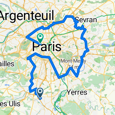
- Chilly mazarin seine test pavé beauvaix 106km
- Distance
- 105.6 km
- Ascent
- 563 m
- Descent
- 563 m
- Location
- Longjumeau, ÃŽle-de-France Region, France
- parcour famille
- Distance
- 8.1 km
- Ascent
- 142 m
- Descent
- 152 m
- Location
- Longjumeau, ÃŽle-de-France Region, France
- chilly melun seine 49km
- Distance
- 48.7 km
- Ascent
- 106 m
- Descent
- 131 m
- Location
- Longjumeau, ÃŽle-de-France Region, France
- De Rue d'Effiat 15, Chilly-Mazarin à Allée des Myosotis 5, Chilly-Mazarin
- Distance
- 40.3 km
- Ascent
- 724 m
- Descent
- 762 m
- Location
- Longjumeau, ÃŽle-de-France Region, France
- vtt chilly villejust 47km
- Distance
- 47.4 km
- Ascent
- 885 m
- Descent
- 885 m
- Location
- Longjumeau, ÃŽle-de-France Region, France
- chilly boissy itteville beauvais mennecy 106km
- Distance
- 106.8 km
- Ascent
- 474 m
- Descent
- 474 m
- Location
- Longjumeau, ÃŽle-de-France Region, France
- Easy Dimanche Track In Longjumeau
- Distance
- 13.5 km
- Ascent
- 49 m
- Descent
- 48 m
- Location
- Longjumeau, ÃŽle-de-France Region, France
Open it in the app