

Baños de Agua Santa
A cycling route starting in Baños, Tungurahua Province, Ecuador.
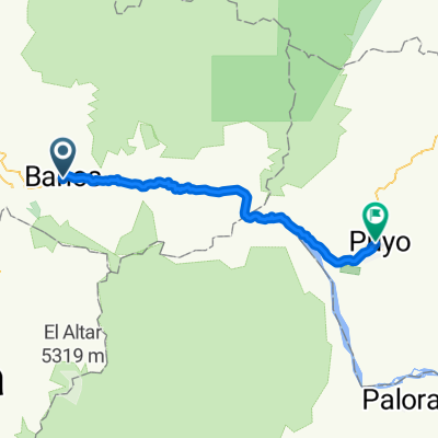
Overview
About this route
tree house - waterfall route - center of Baños
- -:--
- Duration
- 39.2 km
- Distance
- 692 m
- Ascent
- 1,508 m
- Descent
- ---
- Avg. speed
- ---
- Max. altitude

Continue with Bikemap
Use, edit, or download this cycling route
You would like to ride Baños de Agua Santa or customize it for your own trip? Here is what you can do with this Bikemap route:
Free features
- Save this route as favorite or in collections
- Copy & plan your own version of this route
- Sync your route with Garmin or Wahoo
Premium features
Free trial for 3 days, or one-time payment. More about Bikemap Premium.
- Navigate this route on iOS & Android
- Export a GPX / KML file of this route
- Create your custom printout (try it for free)
- Download this route for offline navigation
Discover more Premium features.
Get Bikemap PremiumFrom our community
Other popular routes starting in Baños
 Banos - 7 Wasserfälle - Puyo CLONED FROM ROUTE 9543
- Distance
- 56.3 km
- Ascent
- 819 m
- Descent
- 1,690 m
- Location
- Baños, Tungurahua Province, Ecuador
 Baños - Puyo
- Distance
- 60.1 km
- Ascent
- 677 m
- Descent
- 1,510 m
- Location
- Baños, Tungurahua Province, Ecuador
 Banos -Río Verde- Puyo
- Distance
- 56.3 km
- Ascent
- 814 m
- Descent
- 1,685 m
- Location
- Baños, Tungurahua Province, Ecuador
 Baños (antenas al norte)
- Distance
- 8.3 km
- Ascent
- 1,042 m
- Descent
- 40 m
- Location
- Baños, Tungurahua Province, Ecuador
 LOS PAJAROS -COTALO
- Distance
- 15.1 km
- Ascent
- 1,053 m
- Descent
- 505 m
- Location
- Baños, Tungurahua Province, Ecuador
 Baños - Puyo
- Distance
- 63.3 km
- Ascent
- 1,775 m
- Descent
- 2,652 m
- Location
- Baños, Tungurahua Province, Ecuador
 Planetrek Dia 8
- Distance
- 60.9 km
- Ascent
- 962 m
- Descent
- 1,845 m
- Location
- Baños, Tungurahua Province, Ecuador
 Baños, Patate, Triunfo, Baños
- Distance
- 68.1 km
- Ascent
- 1,714 m
- Descent
- 1,719 m
- Location
- Baños, Tungurahua Province, Ecuador
Open it in the app