

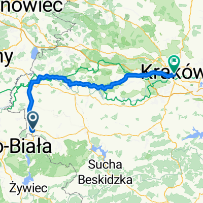
Kety Osvet Krakow
A cycling route starting in Kęty, Lesser Poland Voivodeship, Poland.
Overview
About this route
- -:--
- Duration
- 81.7 km
- Distance
- 162 m
- Ascent
- 218 m
- Descent
- ---
- Avg. speed
- ---
- Max. altitude

Route quality
Waytypes & surfaces along the route
Waytypes
Road
27.8 km
(34 %)
Cycleway
20.4 km
(25 %)
Surfaces
Paved
65.3 km
(80 %)
Unpaved
9 km
(11 %)
Asphalt
62.9 km
(77 %)
Gravel
3.3 km
(4 %)
Continue with Bikemap
Use, edit, or download this cycling route
You would like to ride Kety Osvet Krakow or customize it for your own trip? Here is what you can do with this Bikemap route:
Free features
- Save this route as favorite or in collections
- Copy & plan your own version of this route
- Split it into stages to create a multi-day tour
- Sync your route with Garmin or Wahoo
Premium features
Free trial for 3 days, or one-time payment. More about Bikemap Premium.
- Navigate this route on iOS & Android
- Export a GPX / KML file of this route
- Create your custom printout (try it for free)
- Download this route for offline navigation
Discover more Premium features.
Get Bikemap PremiumFrom our community
Other popular routes starting in Kęty
 Osiedle 700-lecia 15C, Kęty do Osiedle 700-lecia 15C, Kęty
- Distance
- 12.7 km
- Ascent
- 53 m
- Descent
- 53 m
- Location
- Kęty, Lesser Poland Voivodeship, Poland
 2018/13 Żar do Porąbki
- Distance
- 49.7 km
- Ascent
- 861 m
- Descent
- 862 m
- Location
- Kęty, Lesser Poland Voivodeship, Poland
 Kety Osvet Krakow
- Distance
- 81.7 km
- Ascent
- 162 m
- Descent
- 218 m
- Location
- Kęty, Lesser Poland Voivodeship, Poland
 Tadeusza Kościuszki 53A, Kęty do Henryka Sienkiewicza 4, Kęty
- Distance
- 8.3 km
- Ascent
- 44 m
- Descent
- 48 m
- Location
- Kęty, Lesser Poland Voivodeship, Poland
 hhhjjjjjjj
- Distance
- 50.2 km
- Ascent
- 605 m
- Descent
- 616 m
- Location
- Kęty, Lesser Poland Voivodeship, Poland
 Do zapory
- Distance
- 23.2 km
- Ascent
- 102 m
- Descent
- 103 m
- Location
- Kęty, Lesser Poland Voivodeship, Poland
 Starą Drogą do Czańca
- Distance
- 24.8 km
- Ascent
- 145 m
- Descent
- 145 m
- Location
- Kęty, Lesser Poland Voivodeship, Poland
 Kęty-Kozy-Przegibek-
- Distance
- 89.3 km
- Ascent
- 967 m
- Descent
- 960 m
- Location
- Kęty, Lesser Poland Voivodeship, Poland
Open it in the app